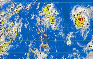
Storm ‘Huaning’ inching closer to Philippines
MANILA, Philippines—The storm that is forecast to enter the country by Wednesday has inched closer to the Philippine area of responsibility (PAR), the state weather bureau said Tuesday morning.
The storm, with international name Soulik, was last observed 1,780 kilometers east of Basco, Batanes, the Philippine Atmospheric Geophysical and Astronomical Services Administration said.
It said the storm was packing maximum sustained winds of 110 kilometers per hour near the center and gusts of up to 140 kph. It was moving at 20 kph.
The storm will be called “Huaning” once it enters the PAR by midday Wednesday. It is seen to affect extreme northern Luzon.
According to the Joint Typhoon Warning Center, however, Soulik is now categorized as a typhoon.
Article continues after this advertisementPagasa’s morning weather bulletin said, “Mimaropa, Ilocos Region, Zamboanga Peninsula, Soccsksargen and northern Mindanao will experience cloudy skies with light to moderate rainshowers and thunderstorms.”
Article continues after this advertisementMetro Manila and the rest of the country will be partly cloudy to cloudy with isolated rainshowers or thunderstorms, it added.
Light to moderate winds blowing from the northeast to north will prevail over Luzon and coming from the northwest to southwest over Visayas and Mindanao. The coastal waters throughout the archipelago will be slight to moderate, it also said.
Meanwhile, an intertropical convergence zone continues to affect Palawan and Mindanao.
