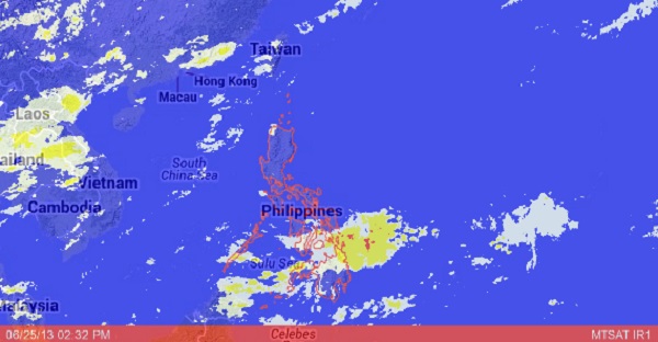
MANILA—Doesn’t it feel like summer? That’s because the country is on a “monsoon break,” except for Mindanao, where a new low-pressure area appears to be forming again, a weather forecaster said on Tuesday.
The weather in Luzon and most parts of the Visayas is predicted to remain fair with isolated rains and thunderstorms in the next few days due to the weak southwest monsoon, the Philippine Atmospheric, Geophysical and Astronomical Services Administration (Pagasa) said.
But a new weather disturbance threatens to form within the Intertropical Convergence Zone (ITCZ) affecting southern Mindanao, Pagasa forecaster Jori Loiz said.
If it turns into a low pressure area, there’s a chance it will move up, push the ridge of high-pressure area prevailing over Luzon, and pull the southwest monsoon back, Loiz said.
“Right now we’re on a monsoon break, so the skies are probably going to be clear in the next few days, except for isolated rains in Luzon and Visayas,” he said. A monsoon break is not unusual and can last for weeks, he said.
“It’s only Mindanao that’s now experiencing a lot of rains,” Loiz said.
Even so, Pagasa issued a thunderstorm advisory over Metro Manila on Tuesday afternoon after it detected thick clouds approaching the metropolis.
Based on the weather bureau’s outlook for Wednesday, Mindanao will experience cloudy skies with light to moderate rain showers and thunderstorms due to the ITCZ affecting its southern parts.
Metro Manila and the rest of the country will be partly cloudy to at times cloudy with isolated rain showers or thunderstorms mostly in the afternoon or evening.
Light to moderate winds blowing from the east to southeast will prevail over Luzon and Visayas and the winds coming from the east to northeast will prevail over Mindanao, Pagasa said.
Coastal waters throughout the archipelago will be slight to moderate, it added.
