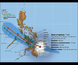
Pablo, the sixteenth storm to enter the Philippine territory for the year, continued to spawn heavy to intense rains within its 500-kilometer radius, the Philippine Atmospheric Geophysical and Astronomical Services Administration said.
The powerful storm was last seen 60 km southeast of Dumaguete City, packing sustained winds of 160 kilometers per hour near the center and gustiness of up to 195 kph.
It continued to move west northwest at 24 kph.
The following areas were placed under storm signal:
Signal No. 3
Northern Palawan including Calamian Group of Islands
Bohol
Siquijor
Southern Cebu
Negros Oriental
Southern Negros Occidental
Iloilo
Guimaras
Antique
Lanao del Norte
Misamis Occidental
Zamboanga del Norte
Signal No. 2
Rest of Palawan
Aklan
Capiz
Rest of Cebu including Camotes Island
Rest of Negros Occidental
Misamis Oriental
Agusan del Norte
Bukidnon
Lanao del Sur
Zamboanga del Sur including Sibugay
Signal No. 1
Occidental Mindoro
Oriental Mindoro
Romblon
Leyte incl. Biliran
Southern Leyte
Surigao del Norte incl. Siargao
Surigao del Sur
Dinagat
Agusan del Sur
Davao del Norte
Compostela Valley
North Cotabato
Maguindanao
Fishing boats and other sea vessels were still advised not to venture out into the seaboards of Visayas and Mindanao.
Pablo, which made landfall in Davao Oriental early Tuesday, was forecast to be at 140 km Southwest of Coron, Palawan by Wednesday afternoon; 450 km West of Subic, Zambales by Thursday afternoon and 660 km Northwest of Iba, Zambales by Friday afternoon, Pagasa said.