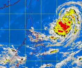
As Tropical Storm “Nina” (international name: Prapiroon) swept before noon Monday into the Philippine area of responsibility (PAR), a low pressure area as well as the intertropical convergence zone (ITCZ) will bring more rains, the weather bureau said.
Philippine Atmospheric, Geophysical and Astronomical Services Administration (Pagasa) forecaster Bernie de Leon said the LPA and the ITCZ would affect the country more than Nina, which is still too far away.
As of 4 p. m. MOnday, the eye of Nina was estimated at 1,210 kilometers east of Cagayan packing maximum winds of 95 kilometers per hour near the center and gustiness of up to 120 kph and moving westward at 9 kph.
De Leon noted that the tropical storm was moving slowly but had gained strength since it entered the PAR at around 10 a.m. Monday with maximum sustained winds of 75 kph near the center and gustiness of up to 90 kph.
Estimated rainfall amount is moderate to heavy (five to ten mm per hour) within the 500-km diameter of the tropical storm.
However, no public storm warning signal has been raised since the storm remains too far away to have any effect.
The LPA was detected at 100 km northeast of Virac, Catanduanes, and was anticipated to bring occasional light to moderate rains or thunderstorms over Cagayan, Isabela and Aurora.
Palawan and the Visayas are expected to have occasional light to moderate rains or thunderstorms due to the ITCZ.
Metro Manila, Central Luzon, the Ilocos provinces, the Cordillera Administrative Region as well as the Calabarzon and Bicol regions are expected to be partly cloudy with brief rainshowers or thunderstorms mostly in the afternoon or evening.
De Leon told the Philippine Daily Inquirer that while the LPA was anticipated to bring rains, it showed no signs of developing into a tropical cyclone and dissipate by Tuesday.
In its forecast, Pagasa said that moderate to strong winds blowing from the northeast to north would prevail over the CAR, Cagayan Valley, Ilocos region, Central Luzon and Metro Manila and the coastal waters along these areas will be moderate to rough.
