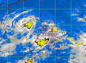
Storm signals still up in Bataan, Zambales; more rains seen
Storm signals were raised over Bataan and Zambales as Tropical Storm “Marce” approached western portions of Luzon Wednesday. But weather forecasters predict it will make a U-turn and leave the country by Friday.
The Philippine Atmospheric, Geophysical and Astronomical Services Administration (Pagasa), however, warned of moderate to heavy rains in Metro Manila and nearby provinces as the storm would further intensify the southwest monsoon.
At 10 p.m., the eye of the storm was observed based on satellite and surface data at 240 kilometers west of Iba town in Zambales, packing maximum sustained winds of 95 kilometers per hour near the center and gustiness of up to 120 kph, Pagasa said.
Marce was forecast to move southeast at a slow 3 kph.
By Thursday morning, the storm is expected to be at 455 kilometers west of Ambulong, Batangas, and by Friday morning, at 650 kilometers west of Metro Manila, outside the Philippine area of responsibility.
Article continues after this advertisementNumerical models showed there was only a small chance Marce would hit land, and that it would likely curve or “make a U-turn” and exit toward Vietnam, Pagasa forecaster Aldczar Aurelio said.
If it makes landfall, however, the storm will affect Zambales or Bataan, he said. He added that the southwest monsoon (locally known as “habagat”) enhanced by the storm will continue to bring moderate to heavy rains in Luzon including Metro Manila and the Visayas.
