‘Marce’ slightly intensifies; yellow warning still up in metro
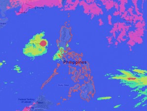
MANILA, Philippines–Tropical Storm Marce has continued to move slowly southeastward and has slightly intensified, the state weather bureau said Wednesday.
The center of Marce was last seen 270 kilometers west of Iba, Zambales with maximum sustained winds of 85 kilometers per hour near the center and gustiness of up to 100 kph as of 10 a.m., the Philippine Atmospheric Geophysical and Astronomical Services Administration said.
The storm was forecast to move southeast at 7 kph, and was seen to exit by Friday.
Marce will bring moderate to heavy rains within 400 koilometers and will enhance the southwest monsoon.
It will continue to bring occasional moderate to heavy rains over Metro Manila, Central Luzon, MIMAROPA, CALABARZON and Bicol region.
Article continues after this advertisementFishing boats and other small seacraft were advised by Pagasa not to venture out into the western seaboard of Luzon.
Article continues after this advertisementMeanwhile, yellow warning was issued anew in Metro Manila as of 11a.m.
Moderate to heavy rains were seen to continue in the next three hours.
