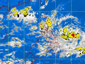
MANILA, Philippines—A weather disturbance east of the country developed into a tropical storm named “Lawin” on Friday but the state weather bureau said it was still too far away to be felt.
As of 10 a.m. Friday, no public storm signals have been raised in the Philippines.
The eye of the storm was observed 600 kilometers east of Virac, Catanduanes, moving in a west-southwest direction at 11 kph, the Philippine Atmospheric, Geophysical and Astronomical Services Administration said.
Lawin, which developed from a low pressure area and then a tropical depression east of the Philippines, was packing sustained winds of 75 kph near the center, and gustiness of up to 90 kph, the weather bureau said.
Pagasa said the storm would spawn moderate to intense rains at 10-20 mm per hour in an area within 300 km of its center.
“Tropical Storm Lawin is still far to directly affect any part of the country,” it said in an advisory.
The storm is expected to be 415 km east of Legazpi City by Saturday morning. By Sunday morning, it will be 250 km northeast of Legazpi City and 370 km northeast of Infanta, Quezon, by Monday morning, Pagasa said.
Based on the bureau’s weather outlook, Metro Manila will experience partly cloudy skies with brief rain showers or thunderstorms mostly in the afternoon or evening, while occasional light to moderate rains will be experienced in the Ilocos region and Cagayan valley.
“However, moderate to heavy rains will occur in this area during thunderstorms. The rest of the country will have partly cloudy skies with brief rain showers or thunderstorms mostly in the afternoon or evening,” Pagasa said.
It added that moderate to strong winds blowing from the east will prevail over extreme Northern Lizon and its coastal waters will be moderate to rough. Elsewhere, winds will be light to moderate coming from the southwest to west with slight to moderate seas, it said.
