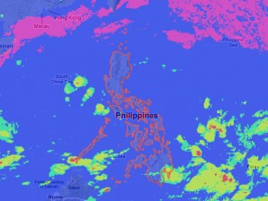
MANILA, Philippines – A new potential cyclone embedded with a wind system was spotted off near Mindanao and will bring rains, the state weather bureau said Monday.
The low pressure area was seen 960 kilometers east of Mindanao embedded along the intertropical convergence zone affecting Visayas and Mindanao, the Philippine Atmospheric Geophysical and Astronomical Services Administration said.
Visayas and Mindanao will experience cloudy skies with scattered rainshowers and thunderstorms becoming widespread rains over Eastern Visayas and Mindanao, which may trigger flashfloods and landslides.
Meanwhile, Luzon will have mostly cloudy skies with scattered rainshowers and thunderstorms, Pagasa said.
Coastal waters will be moderate to rough in Northern Luzon caused by moderate to strong winds blowing from the southeast.
Elsewhere, winds will be light to moderate coming from the southwest to southeast with slight to moderate seas.
