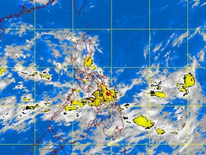
The low pressure area (LPA) initially detected off eastern Samar and moving northward may develop into a tropical depression as it continues to gain strength, the Philippine Atmospheric, Geophysical and Astronomical Services Administration (Pagasa) said Sunday.
The weather bureau said the LPA was expected to enhance the “habagat” (southwest monsoon) and bring widespread rains and thunderstorms over northern Luzon, particularly Baguio, Laoag, and Tuguegarao cities. The rains could trigger flash floods and landslides, it warned.
As of 2 p.m. Sunday, satellite and surface data of the weather bureau showed that the LPA was 535 kilometers east of Virac, Catanduanes.
In its forecast, Pagasa said Central Luzon, Eastern Visayas and Mindanao would experience mostly cloudy skies with scattered rain showers and thunderstorms.
Other parts of the country, including Metro Manila, are expected to have partly cloudy to cloudy skies with isolated rain showers or thunderstorms.
Weather forecaster Adczar Aurelio told the Philippine Daily Inquirer that as long as the LPA remained over the ocean, it would gain strength and could develop into a tropical depression. Jeannette I. Andrade
