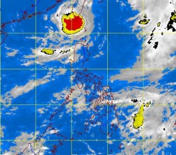
Stronger ‘Igme’ returns to northern Luzon
A considerably faster-moving Typhoon “Igme” (international name Tembin) reentered the Philippine area of responsibility early Monday to pound extreme northern Luzon with rains and strong winds, prompting the Philippine Atmospheric, Geophysical and Astronomical Services Administration (Pagasa) to hoist a public storm warning signal over the Batanes group of islands.
While alerting the public about Igme’s return, the weather bureau said the habagat (southwest monsoon), enhanced by Typhoons Igme and “Julian” (Bolaven), is expected to pose a bigger threat as Pagasa warned of possible flashfloods and landslides in northern Luzon and the western section of Central Luzon that could be triggered by occasional moderate to heavy rains (three mm to 12 mm per hour) with strong winds.
Gusty winds of 30 to 60 kilometers per hour and moderate to heavy (10 mm to 20 mm per hour) rains within the 600-kilometer area of the typhoon are expected, particularly in the Batanes, Calayan and Babuyan group of islands, where rough to very rough coastal waters are anticipated.
The enhanced monsoon is likewise expected to bring light to moderate (two mm to 7.5 mm per hour) rains over Central Luzon, particularly over its western section and Metro Manila, where mostly cloudy skies with scattered rain showers and thunderstorms are to be anticipated.
Weather forecaster Buddy Javier told the Philippine Daily Inquirer that Igme had gained speed due to its continuing interaction with Julian.
Article continues after this advertisement“It is being pulled by Julian northwards back towards Taiwan,” he said. For several days, the typhoon was described by forecasters to be almost stationary.
Article continues after this advertisementJavier said Igme may further intensify but it was not anticipated to make landfall in the country. “It may possibly make landfall in Taiwan,” he said.
At 4 p.m. Monday, the eye of the typhoon was estimated at 310 km west northwest of Basco, Batanes, with maximum sustained winds of 140 kph near the center and gustiness of up to 170 kph moving northeast at 13 kph.
By Wednesday afternoon, Igme is expected to be 560 km north northeast of Basco, or 150 km northeast of Taipei.
Meanwhile, in its forecast, the weather bureau anticipated the western section of southern Luzon to have mostly cloudy skies with scattered rain showers and thunderstorms while the rest of the country will be partly cloudy to cloudy with isolated rain showers or thunderstorms.
Moderate to strong winds blowing from the southwest will prevail over Luzon and the Visayas and the coastal waters along these areas will be moderate to rough. Elsewhere, winds will be light to moderate coming from the south to southwest with slight to moderate seas.
Strong to gale force winds associated with Igme and Julian are expected to make sea conditions in the seaboards of northern Luzon in the provinces of Cagayan, the Ilocos provinces, La Union, Pangasinan, and Central Luzon in Aurora, Zambales and Bataan to be rough to very rough.
