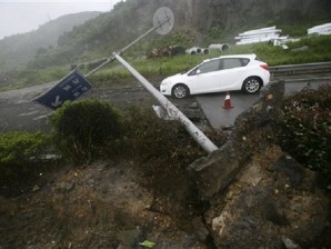
In this photo released by China’s Xinhua News Agency, a road sign is blown down in Xiangshan County, east China’s Zhejiang Province, Wednesday, Aug. 8, 2012. Typhoon Haikui slammed into eastern Zhejiang province early Wednesday, packing winds up to 150 kilometers (90 miles) per hour and triggering flooding. AP/Xinhua, Zhang Peijian
The remnants of Tropical Storm Haikui will continue spinning over southeastern China on Friday. Counter-clockwise flow around the system will pull more moisture onshore from the East China Sea, producing more showers and thunderstorms across the region. Expect Shanghai to see more rain showers with a chance of thunderstorms and highs near 30 degrees Celsius. This system will also push moisture eastward into the Korean Peninsula, producing widespread showers and thunderstorms throughout the day. Beijing will be just north of this system under partly cloudy skies with highs near 32 C.
To the east, Tropical Storm Kirogi will lose strength as it moves northward through the North Pacific Ocean and toward the Kuril Islands. The system will reduce to tropical depression strength by Friday, but will bring heavy rains and strong winds to far northern Japan and the Kuril Islands throughout the day. Tokyo will see decreasing clouds and dry conditions with highs in the low 30s C.
A strong low pressure system spinning just offshore of eastern Australia will maintain coastal showers across New South Wales and Queensland. Expect Sydney to see scattered showers and cooler conditions with highs in the mid-teens C. High pressure over the rest of the country will produce another hot and dry day.