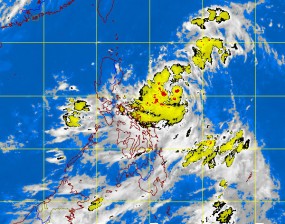
‘Ferdie’ merges with LPA before exiting PH
MANILA, Philippines – Tropical Depression “Ferdie”, which on Saturday battered Northern Luzon provinces with heavy rain, merged with a low pressure area before swirling out of the Philippine area of responsibility.
Heavy rain swelled rivers and creeks, triggering flashfloods in low-lying areas and landslides in mountainous areas in Northern Luzon. Monsoon rains, enhanced by Ferdie, flooded parts of Metro Manila, prompting the suspension of classes in some colleges.
The Philippine Atmospheric Geophysical and Astronomical Services Administration recorded heavy to intense rainfall from Mindoro to farther north in Mountain Province and Ilocos Sur, from Friday morning to Saturday morning.
Sinait, Ilocos Sur posted the highest 24-hour rainfall at 190.6 millimeters, followed by Subic Bay’s 107.9 mm, Sangley Point’s 91.6 mm, Baguio City’s 84.6 mm and Calapan’s 80 mm.
In the capital, the weather bureau on Saturday morning issued warnings of serious flooding in Taguig, Parañaque, Manila, Quezon City, Mandaluyong, San Juan, Pasig, Pasay, Marikina, Malabon, Navotas and Caloocan, after recording 65 mm of rainfall in these areas for the past three hours.
Article continues after this advertisementAfter making landfall in the Batanes and Calayan groups of islands in the northern tip of the archipelago at past midnight Friday, the depression merged with a low pressure area over the West Philippine Sea Saturday morning. This, however, did not have any effect.
Article continues after this advertisementAs it swirled over the sea 130 kilometers northwest of Laoag City 10 a.m. Saturday, Storm Signal No. 1 remained over Ilocos Norte, Ilocos Sur and Abra. Storm signals elsewhere were lowered.
By Saturday night, the depression, with peak winds of 55 kilometers per hour and moving west at 15 kph, was expected to be out of the PAR.
While out of PAR, the weather disturbance will intensify the southwest monsoon to bring rain over the western sections of Luzon and Visayas Sunday, forecaster Gener Quitlong said in an interview.
“We will experience cloudy skies with scattered rainshowers and thunderstorms on Sunday. By Monday, we will have improving weather. There’s a chance the sun will come out but in the afternoon, we’ll experience isolated rainshowers,” Quitlong said.
Residents living in low lying and mountainous areas were alerted against possible flashfloods and landslides due to enhanced southwest monsoon especially the western section of Luzon and Visayas.
Fishing boats and other small seacraft were advised not to venture out into the western seaboard of Luzon due to the combined effect of tropical depression “Ferdie” and the southwest monsoon.
It can intensify into a storm before exiting PAR, but will weaken if this slams into Hong Kong, he said.
