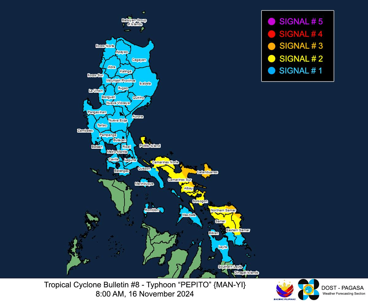
Tropical Cyclone Wind Signals for Typhoon Pepito (international name: Man-yi) as of 8 a.m., November 16, 2024. Photo from Pagasa
MANILA, Philippines — Typhoon Pepito (international name: Man-yi) remained on track to become a super typhoon, sustaining its strength and prompting Tropical Cyclone Wind Signals from Luzon to Mindanao.
As it gets closer to the landmass, the Philippine Atmospheric, Geophysical and Astronomical Services Administration (Pagasa) raised TCWS No. 3 over:
Luzon
- Catanduanes
- Eastern portion of Albay (Rapu-Rapu, Bacacay, Santo Domingo, City of Tabaco, Malilipot, Tiwi, Malinao)
- Eastern portion of Camarines Sur (Caramoan, Presentacion, San Jose, Garchitorena, Lagonoy, Sagñay, Tigaon, Goa, Tinambac, Siruma)
- Easternmost portion of Sorsogon (Prieto Diaz)
Visayas
- Eastern portion of Northern Samar (Palapag, Laoang, Mapanas, Gamay, Lapinig, Catubig, Pambujan)
- Northernmost portion of Eastern Samar (San Policarpo, Arteche, Oras, Jipapad)
These places may anticipate wind speeds between 89 kilometer per hour (kph) and 117 kph in the next 18 hours, based on the 8 a.m. cyclone bulletin of Pagasa. Such wind speeds pose moderate to significant threat to persons and property.
Pagasa likewise declared TCWS No. 2 in:
Luzon
- Rest of Camarines Sur
- Rest of Albay
- Rest of Sorsogon
- Ticao Island
- Camarines Norte
- Northeastern portion of Quezon (Perez, Alabat, Quezon, Calauag, Guinayangan, Tagkawayan) including Polillo Islands
Visayas
- Northern portion of Eastern Samar (Dolores, Maslog, Can-Avid, Taft, Sulat, San Julian, City of Borongan)
- Northern portion of Samar (Matuguinao, Calbayog City, Santa Margarita, San Jorge, San Jose de Buan, Tarangan, Motiong, Gandara, Jiabong, City of Catbalogan, Paranas, Hinabangan, San Sebastian, Pagsanghan)
- Rest of Northern Samar
Wind speeds from 62 kph to 88 kph, which may cause minor to moderate threat to life and property, can be expected in the next 24 hours.
Pagasa further raised TCWS No. 1 in the following areas:
Luzon
- Rest of Masbate including Burias Island
- Marinduque
- Romblon
- Rest of Quezon
- Laguna
- Rizal
- Cavite
- Batangas
- Metro Manila
- Zambales
- Bataan
- Bulacan
- Pampanga
- Tarlac
- Nueva Ecija
- Aurora
- Quirino
- Nueva Vizcaya
- Isabela
- Mainland Cagayan
- Pangasinan
- La Union
- Ilocos Sur
- Ilocos Norte
- Abra
- Apayao
- Kalinga
- Mountain Province
- Ifugao
- Benguet
Visayas
- Rest of Eastern Samar
- Rest of Samar
- Biliran
- Northern and central portions of Leyte (Tunga, Pastrana, San Miguel, Matag-Ob, Tolosa, Palo, Calubian, Leyte, Mayorga, Julita, Carigara, Babatgon, Dagami, Jaro, San Isidro, Santa Fe, Albuera, Villaba, La Paz, Palompon, Macarthur, Tabontabon, Tanauan, Merida, Ormoc City, Isabel, Dulag, Capoocan, Alangalang, Burauen, Tabango, Tacloban City, Kananga, Barugo, Abuyog, Javier, City of Baybay, Mahaplag)
- Northeastern portion of Southern Leyte (Silago)
- Northernmost portion of Cebu (Daanbantayan, Medellin) including Bantayan Islands
- Northernmost portion of Iloilo (Carles)
Mindanao
- Northern portion of Dinagat Islands (Loreto, Tubajon)
These localities may see wind speeds of 39 kph to 61 kph in the next 36 hours, according to Pagasa.
The state weather agency said in its 8 a.m. cyclone bulletin that Pepito maintained its strength, packing maximum sustained winds of 175 kph and gustiness of 215 kph at its last location some 235 kms east of Catarman, Northern Samar. Pepito was heading northwest at 25 kph.
Pagasa likewise retained its projection that Pepito will hit the vicinity of Catanduanes either Saturday evening or Sunday early morning, November 17, and become a super typhoon before landfall.
Pagasa said Pepito will pass through the Bicol Region, Calabarzon, Central Luzon, Cordillera Administrative Region, and Ilocos Region before emerging at the West Philippine Sea. Pepito is anticipated to leave Philippine area of responsibility by Monday, November 18.