MANILA, Philippines — The Bicol Region, which is still reeling from the effects of Tropical Storm Kristine (international name: Trami), will be among the areas on the path of Severe Tropical Storm Pepito (international name: Man-yi), a potential super typhoon that is anticipated to hit the country this weekend.
Daniel James Villamil, a weather specialist of the Philippine Atmospheric, Geophysical and Astronomical Services Administration (Pagasa), said during the Friday morning weathercast that Pepito’s “confidence cone” is wide and covers portions of Central Luzon, Southern Luzon, including the Bicol Region, and Eastern Visayas. These areas, he noted, have a high chance of being affected by Pepito’s landfall or direct hit.
Although current data shows Pepito’s “southward shift” track, Villamil said they are not discounting the possibility that the weather disturbance will make landfall in the eastern coasts of Central Luzon, Southern Luzon, or Eastern Visayas.
Villamil added that Pagasa may raise the highest Tropical Cyclone Wind Signal (TCWS) No. 5 for Pepito.
READ: Pepito to become typhoon in 12 hrs, hit land at peak intensity

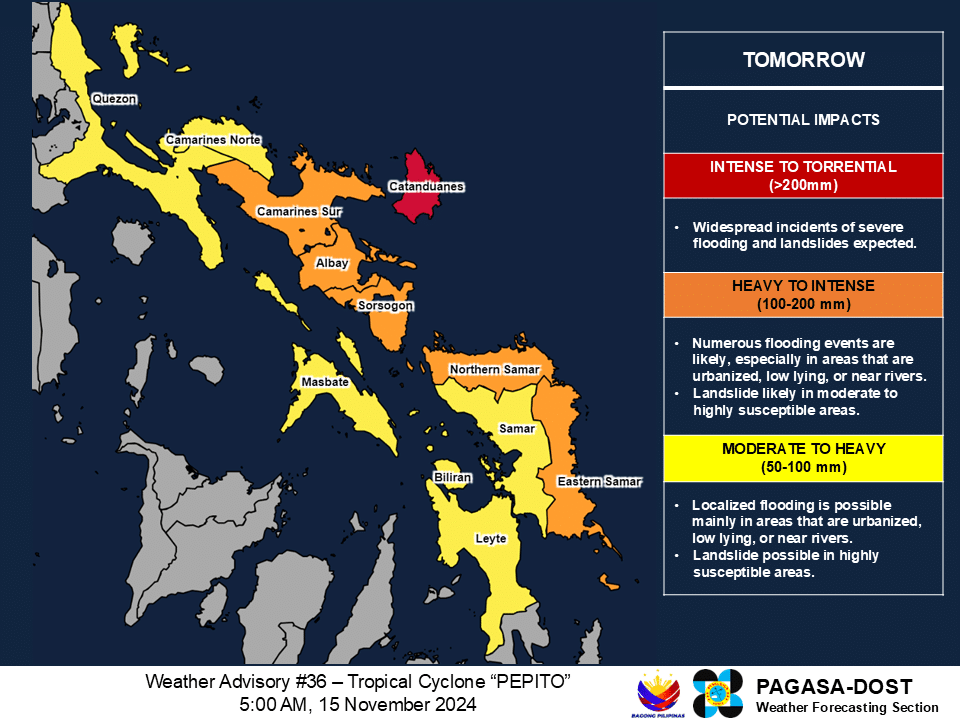
Forecast rainfall for Severe Tropical Storm Pepito (international name: Man-yi), a potential super typhoon that is anticipated to hit the country this weekend, November 15016, 2024. Photo from Pagasa
Pepito “is forecast to intensify into a typhoon within the next 12 hours” and gain more strength to become a super typhoon by Saturday evening, November 16.
Pagasa said Pepito may make landfall at peak intensity.
READ: LIVE UPDATES: Typhoon Ofel and Severe Tropical Storm Pepito
Villamim likewise said that “intense to torrential” rainfall of more than 200 millimeters (mm) that may cause “widespread incidents of severe flooding and landslides” is forecast to occur while Pepito gets closer to the country’s landmass.
“In anticipation of the approaching Pepito, we expect that as early as tomorrow (Saturday, November 15), we will experience heavy rains in a big part of Southern Luzon, [an] area of Bicol Region, as well as Eastern Visayas,” Villamil said in mixed Filipino and English.
Forecast rainfall for Severe Tropical Storm Pepito (international name: Man-yi), a potential super typhoon that is anticipated to hit the country this weekend, November 15016, 2024. Photo from Pagasa
According to the 5 a.m. cyclone bulletin of Pagasa, Pepito was last located 795 kilometers east of Guiuan, Eastern Samar, moving westward at 25 kilometers per hour (kph) and packing maximum sustained winds of 110 kph and gustiness of up to 135 kph.
By Saturday, Pepito is seen to trigger intense to torrential rains (more than 200 mm) in Catanduanes; and heavy to intense rains of 100 to 200 mm in Camarines Sur, Albay, Sorsogon, Northern Samar, and Eastern Samar.
It is also predicted that intense torrential rains will persist in Catanduanes on Sunday, as well as in Camarines Sur, Camarines Norte, Quezon Province, and Aurora.
Also on Sunday, heavy to intense rains ranging from 100 mm to 200 mm is anticipated to occur in Nueva Ecija, Bulacan, Rizal, Laguna, Marinduque, Albay, Sorsogon, and Northern Samar.
Meanwhile, moderate to heavy rains ranging from 50 mm to 100 mm are expected in Metro Manila, Cavite, Pampanga, Batangas, Bataan, Tarlac, Zambales, Pangasinan, Nueva Vizcaya, Quirino in Luzon; and Samar, Eastern Samar, Masbate, Romblon and Oriental Mindoro in Visayas on Sunday.
Kristine lashed the Bicol Region in late October, claiming lives, interrupting services, and devastating properties and agricultural lands.

