Marce weakens as it crosses Ilocos Norte; to exit PAR within hours

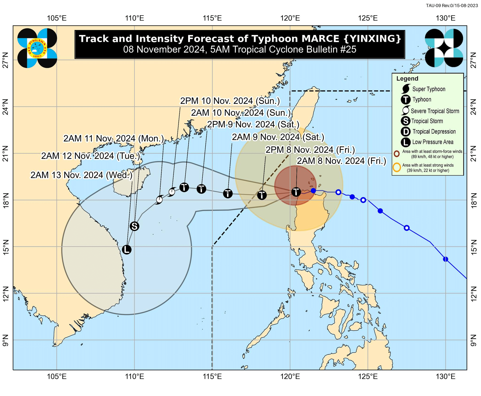
Track and intensity forecast of Typhoon Marce (international name: Yinxing) as of 5 a.m. on Friday, November 8, 2024. – Marce continued to weaken as it crossed Ilocos Norte early Friday morning, the Philippine Atmospheric, Geophysical and Astronomical Services Administration (Pagasa) said. (Photo from Pagasa/Facebook)
MANILA, Philippines — Typhoon Marce (international name: Yinxing) continued to weaken as it crossed Ilocos Norte early Friday morning, the Philippine Atmospheric, Geophysical and Astronomical Services Administration (Pagasa) said.
In its 5 a.m. weather bulletin, Pagasa noted that Marce was last located over the coastal waters of Pasuquin municipality, moving west-northwestward at 10 kilometers per hour (kph).

Marce was packing maximum sustained winds of 155 kph and gustiness of up to 215 kph.
READ: Marce pounds Northern Luzon; Cagayan folk flee homes
Marce first made landfall at Sta. Ana, Cagayan, at 3:40 p.m. on Thursday, and then at the coast of northwestern Cagayan on Thursday evening.
Pagasa said Marce “will continue moving generally westward and exit the Philippine area of responsibility (PAR) region this [Friday] afternoon or evening.”
Despite Typhoon Marce’s weakening, the state weather agency hoisted Tropical Cyclone Wind Signals (TCWS) in different areas of Luzon, as follows:
TCWS No. 4
- Ilocos Norte
- The northernmost portion of Ilocos Sur (Sinait, Cabugao)
- The northern portion of Abra (Danglas, Lagayan, Tineg)
- The northwestern portion of Apayao (Calanasan)
- The northwestern portion of mainland Cagayan (Sanchez-Mira, Claveria, Santa Praxedes)
TCWS No. 3
- The southern and western portion of Babuyan Islands (Fuga Is., Dalupiri Is., Calayan Is., Camiguin Is.)
- The northern and western portions of Cagayan (Piat, Santo Niño, Rizal, Aparri, Lasam, Camalaniugan, Buguey, Santa Teresita, Allacapan, Pamplona, Abulug, and Ballesteros)
- The rest of Apayao
- The central portion of Abra (Lacub, San Juan, La Paz, Bangued, Langiden, San Quintin, Pidigan, Malibcong, Peñarrubia, Bucay, Licuan-Baay, Langailang, Dolores, Tayum, Sallapadan, San Isidro)
- The northern portion of Ilocos Sur (Santo Domingo, San Vicente, Santa Catalina, Bantay, San Ildefonso, City of Vigan, Caoayan, Santa, Narvacan, Nagbukel, Magsingal, San Juan)
TCWS No. 2
- Southern portion of Batanes (Mahatao, Uyugan, Basco, Ivana, Sabtang)
- Rest of the Babuyan Islands
- Rest of mainland Cagayan
- Northern and western portions of Isabela (San Pablo, Santa Maria, Tumauini, Maconacon, Cabagan, Santo Tomas, Quezon, Mallig, Delfin Albano, Quirino, Gamu, Roxas, Burgos, Reina Mercedes, Luna, Aurora, San Manuel, San Mateo, Cabatuan)
- Rest of Abra
- Kalinga
- Mountain Province
- Northern portion of Ifugao (Alfonso, Lista, Aguinaldo, Mayoyao, Banaue, Hungduan)
- Northern portion of Benguet (Bakun, Mankayan)
- Rest of Ilocos Sur
- Northern portion of La Union (Sudipen, Bangar, Balaoan, Luna, Santol, Bacnotan)
READ: Typhoon Marce’s next landfall expected over Cagayan coast in a few hours
TCWS No. 1
- Rest of Batanes
- Rest of La Union
- Pangasinan
- Rest of Ifugao
- Rest of Benguet
- Rest of Isabela
- Quirino
- Nueva Vizcaya
- Northern and central portions of Aurora (Dilasag, Casiguran, Dinalungan, Dipaculao)
- Northern portion of Nueva Ecija (Carranglan)
- Northern portion of Zambales (Santa Cruz, Candelaria)
Pagasa likewise raised a storm surge warning over low-lying or coastal communities of:
- Batanes
- Cagayan, including the Babuyan Islands
- Isabela
- Ilocos Norte
- Ilocos Sur
- La Union
A storm surge is possible in these provinces in the next 48 hours due to Marce, it added.
Pagasa also said a gale warning is up over the seaboards of Northern Luzon because “very rough, high, or very high seas” are anticipated on the region’s coasts.