Signal No. 5 raised in parts of Batanes

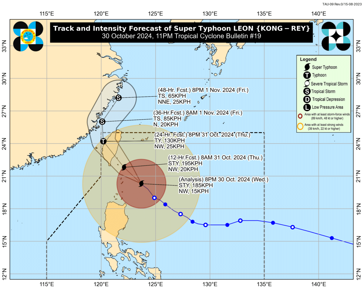
MANILA, Philippines — Tropical Cyclone Wind Signal No. 5 has been raised over the northern and eastern portions of Batanes on Wednesday night as Super Typhoon Leon (international name: Kong-Rey) moves closer to extreme Northern Luzon.
According to Pagasa in its 11 p.m. typhoon bulletin, “violent conditions” are currently being experienced in Batanes due to the effects of Leon.
Under Signal No. 5, typhoon-force winds exceeding speeds of 185 kilometers per hour (km/h) should be expected, posing extreme threat to life and property.
READ: LIVE UPDATES: Super Typhoon Leon
Meanwhile, Signal No. 4 remains hoisted over the rest of Batanes.
As of 10 p.m., Leon was last spotted 140 kilometers east of Basco, Batanes, moving northwestward at 15 km/h—slightly slower than its previous speed of 20 km/h.
Article continues after this advertisementIt continues to carry maximum sustained winds of 185 km/h and gustiness of up to 230 km/h.
Article continues after this advertisementBelow are the other areas currently under Signals No. 3 to 1:
Signal No. 3 (storm-force winds with speeds reaching 89 km/h up to 117 km/h may be in the next 18 hours)
- The eastern portion of Babuyan Islands (Babuyan Is., Camiguin Is., Calayan Is.,) and
- The northeastern portion of mainland Cagayan (Santa Ana)
Signal No. 2 (gale-force 62 kph up to 88 kph in speed expected within 24 hours)
- The rest of Babuyan Islands,
- The rest of mainland Cagayan,
- The northern portion of Isabela (Santo Tomas, Santa Maria, Quezon, Delfin Albano, San Pablo, Ilagan City, Tumauini, Cabagan, Palanan, Quirino, Divilacan, Mallig, Maconacon, Gamu, Burgos, Roxas, San Mariano, Reina Mercedes, San Manuel, Naguilian, Benito Soliven)
- Apayao
- The northern portion of Kalinga (City of Tabuk, Balbalan, Pinukpuk, Rizal)
- The northern portions of Abra (Tineg, Lacub, Malibcong), and
- Ilocos Norte
Signal No. 1 (strong winds 39 to 61 kph in speed expected within 36 hours)
- The rest of Isabela,
- Quirino,
- Nueva Vizcaya,
- The rest of Abra,
- The rest of Kalinga,
- Mountain Province,
- Ifugao,
- Benguet,
- Ilocos Sur,
- La Union,
- The northern and central portions of Pangasinan (Basista, Lingayen, Villasis, City of Alaminos, Anda, Malasiqui, Tayug, San Fabian, Mangaldan, Mapandan, Burgos, Dagupan City, Binalonan, Bolinao, Alcala, San Manuel, Sual, Umingan, Asingan, Labrador, Bani, Santo Tomas, Pozorrubio, San Quintin, Santa Maria, City of Urdaneta, Laoac, Natividad, Mabini, San Carlos City, Manaoag, Binmaley, San Jacinto, Bugallon, Agno, Calasiao, San Nicolas, Santa Barbara, Balungao, Sison, Rosales, Daso), and
- The northern and eastern portions of Nueva Ecija (Bongabon, Carranglan, Pantabangan, Laur, Rizal, Cuyapo, Talavera, Santo Domingo, Llanera, Science City of Mu oz, General Mamerto Natividad, San Jose City, Lupao, Talugtug, Gabaldon)
- The northern and central portions of Aurora (Casiguran, Dinalungan, Baler, Maria Aurora, Dipaculao, San Luis, Dilasag)
Storm Surge
Pagasa also warns that a storm surge may occur, said Pagasa.
“Within the next 48 hours, there is a high risk of life-threatening storm surge with peak heights exceeding 3 meters above normal tide levels over the low-lying or exposed coastal localities of Batanes and Babuyan Islands,” said Pagasa.
A storm surge refers to the abnormal rise in sea level that occurs during tropical cyclones which result in heavy flooding.