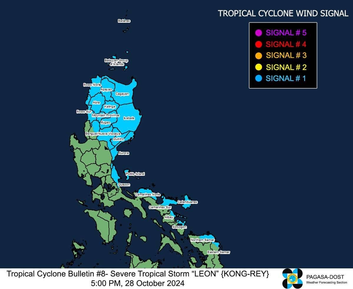
Image from the Philippine Atmospheric, Geophysical and Astronomical Services Administration
MANILA, Philippines — Severe Tropical Storm Leon (international name: Kong-rey) further intensified over the Philippine Sea, prompting the state weather bureau to raise Signal No. 1 over several areas in Luzon and Visayas on Monday afternoon.
According to the Philippine Atmospheric, Geophysical and Astronomical Services Administration’s (Pagasa) 5 p.m. cyclone update, Leon was last spotted 725 kilometers east of Echague, Isabela moving west-northwest at 15 kilometers per hour (kph).
READ: NDRRMC: 116 dead due to Kristine, over 6 million affected
Leon was carrying maximum sustained winds of 100 kph with gusts of up to 125 kph.
Below is the list of areas under Signal No. 1:
Luzon
- Batanes
- Cagayan including Babuyan Islands
- Isabela
- Quirino
- Nueva Vizcaya
- Apayao
- Kalinga
- Abra
- Mountain Province
- Ifugao
- The northern portion of Benguet (Bakun, Kibungan, Atok, Bokod, Mankayan, Buguias, Kabayan)
- Ilocos Norte
- Ilocos Sur
- La Union
- Aurora
- The northern portion of Quezon including Polillo Islands (General Nakar, Infanta, Real)
- Camarines Norte
- The eastern portion of Camarines Sur (Tinambac, Siruma, Goa, Lagonoy, San Jose, Garchitorena, Caramoan, Presentacion, Tigaon, Calabanga, Saglay)
- Catanduanes
- The eastern portion of Albay (Rapu-Rapu, Bacacay, City of Tabaco, Tiwi, Malilipot, Malinao, Santo Domingo, Manito)
- The northeastern portion of Sorsogon (Prieto Diaz, City of Sorsogon, Gubat)
Visayas
-
The eastern portion of Northern Samar (San Roque, Pambujan, Catubig, Palapag, Gamay, Lapihig, Mapanas, Mondragon)
The wind flow from the storm’s circulation will also bring strong to gale-force winds over the Visayas and most of Calabarzon, Mimaropa, Bicol Region, Northern Mindanao, and Caraga Region.
Based on the state weather service’s forecast, Leon is expected to make landfall over the eastern coast of Taiwan by Thursday, October 31, and exit the country’s boundary by Friday, November 1.


