
Track and intensity forecast of Severe Tropical Storm Leon as of October 28, 2024. Courtesy of DOST / Pagasa
MANILA, Philippines — Leon (international name: Kong-rey) intensified into a Severe Tropical Storm on Monday, according to the Philippine Atmospheric, Geophysical and Astronomical Services Administration (Pagasa).
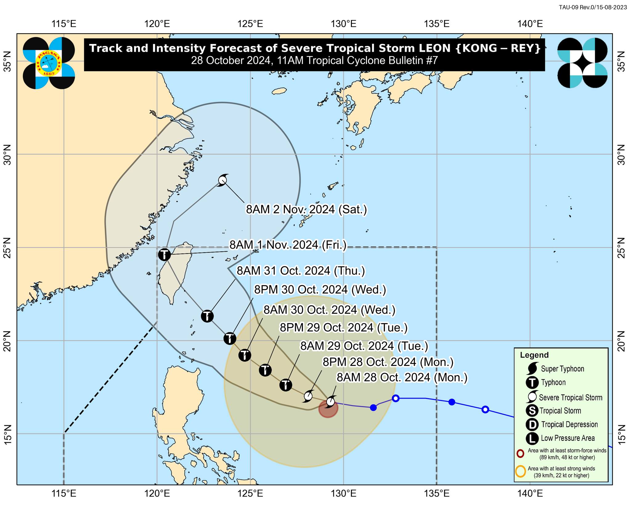
In an 11 a.m. briefing, Pagasa said Leon was last spotted some 735 kilometers (km) east of Casiguran, Aurora, or 780 km east of Echague, Isabela.

In the past six hours, it moved westward at 20 kph, Pagasa Assistant Weather Services Chief Christopher Perez said in a press conference on Monday.
According to Perez, Leon is packing maximum sustained winds of 95 kph near its center and gustiness of up to 115 kph.
“Thick clouds are present on the western and southern sides of Severe Tropical Storm Leon, causing it to continue moving closer to the country in the coming days. Although still offshore, some parts of the country may already experience rainfall,” he added.
Due to Leon intensifying, Pagasa raised Tropical Cyclone Wind Signal (TCWS) No. 1 in the following areas:
- Batanes
- Cagayan, including Babuyan Islands
- Isabela
- Ilocos Norte
- Abra
- Apayao
- Eastern portion of Mountain Province (Natonin, Paracelis)
- Eastern portion of Ifugao (Aguinaldo, Alfonso Lista)
- Eastern portion of Quirino (Maddela)
- Northern portion of Aurora (Dilasag, Casiguran, Dinalungan)
- Northern portion of Catanduanes (Pandan, Bagamanoc, Panganiban, Viga, Gigmoto)
Minimal to minor impacts from strong winds are possible within any of the areas under TCWS No. 1, according to Pagasa.
“The highest wind signal which may be hoisted during the occurrence of Leon is Wind Signal No. 3 or 4, especially in Extreme Northern Luzon,” the state weather bureau added.
Pagasa further noted there is an increasing possibility of a further westward shift in the track forecast of Leon but within the limits of the forecast confidence cone.
A landfall or close approach scenario in Batanes is not ruled out, according to Pagasa.
“Makikita po natin ‘yung sentro ng bagyo ay hindi natin inaasahang tatama, pero ‘yung area of probability, ‘yung parang apa kung saan nakapaloob yung center track, ay nagpapakita na may posibilidad na tumama ito sa either of the Batanes Group of Island or sa Babuyan Group of Island or hindi,” Perez explained.
(We can see that the center of the storm is not expected to make landfall, but the area of probability — the cone encompassing the center track — indicates the possibility of it hitting either the Batanes Group of Islands, the Babuyan Group of Islands, or possibly missing both.)
Severe Tropical Storm Leon is expected to rapidly intensify throughout its passage over the Philippine Sea and may reach the typhoon category within 24 hours.
“Makikita natin sa forecast track na ang bagyo nga ay posibleng maging typhoon bago tuluyang lumapit sa bandang dulong hilagang Luzon,” Perez stated.
(We can see in the forecast track that the severe tropical storm could intensify into a typhoon before it finally approaches the northernmost part of Luzon.)
Furthermore, there is an increasing chance that Leon will reach the super typhoon category during its period of closest approach to Batanes, the state weather bureau noted.
Pagasa stated that a gale warning would be hoisted over the northern and eastern seaboard of northern Luzon on Monday afternoon.
“In the next 24 hours, inaasahan nating pwedeng umabot ng 4.5 meters (m) ang mga karagatan sa paligid ng Batanes, habang up to 4 m naman dito sa karagatan sa paligid ng Babuyan Islands at Isabela, at sa eastern seaboard ng mainland Cagayan,” Perez reported.
(In the next 24 hours, we expect sea levels to reach up to 4.5 meters around Batanes, and up to 4 meters around the waters of the Babuyan Islands, Isabela, and along the eastern seaboard of mainland Cagayan.)
READ: Leon slightly intensifies; Three areas placed under Signal No. 1