Storm Kristine maintains strength; Signal No. 3 still up over 12 areas
READ: LIVE UPDATES: Tropical Storm Kristine
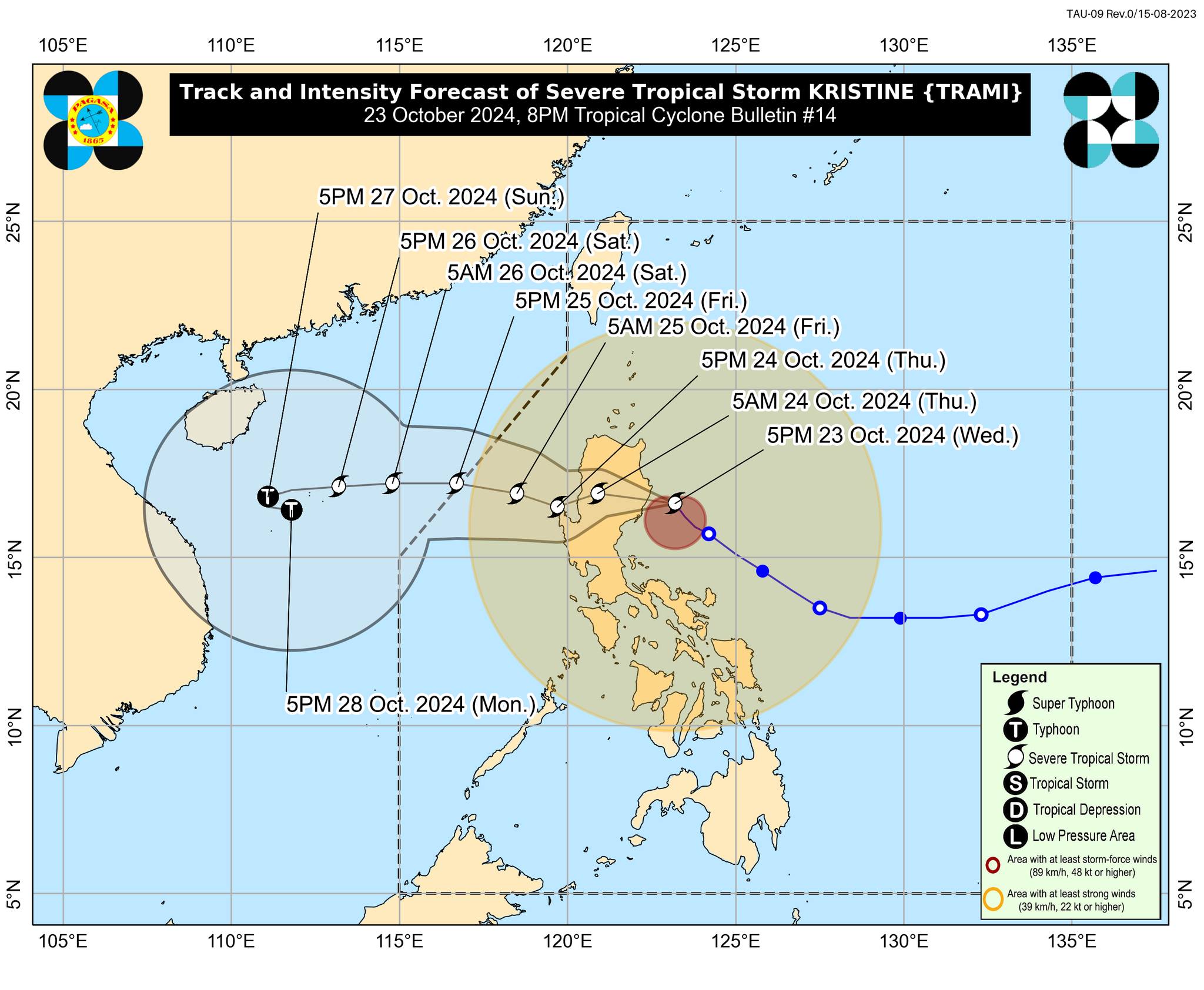
MANILA, Philippines — Severe Tropical Storm Kristine (international name: Trami) maintained its strength as it approached the coastal waters of Isabela, the state weather bureau reported Wednesday evening.
In its 8 p.m. update, the Philippine Atmospheric, Geophysical and Astronomical Services Administration’s (Pagasa) said that Kristine’s center was last monitored some 150 kilometers east of Echague, Isabela, moving northwest at 15 kilometers per hour (kph), and packing maximum sustained winds of 95 kph and gusts of up to 115 kph.
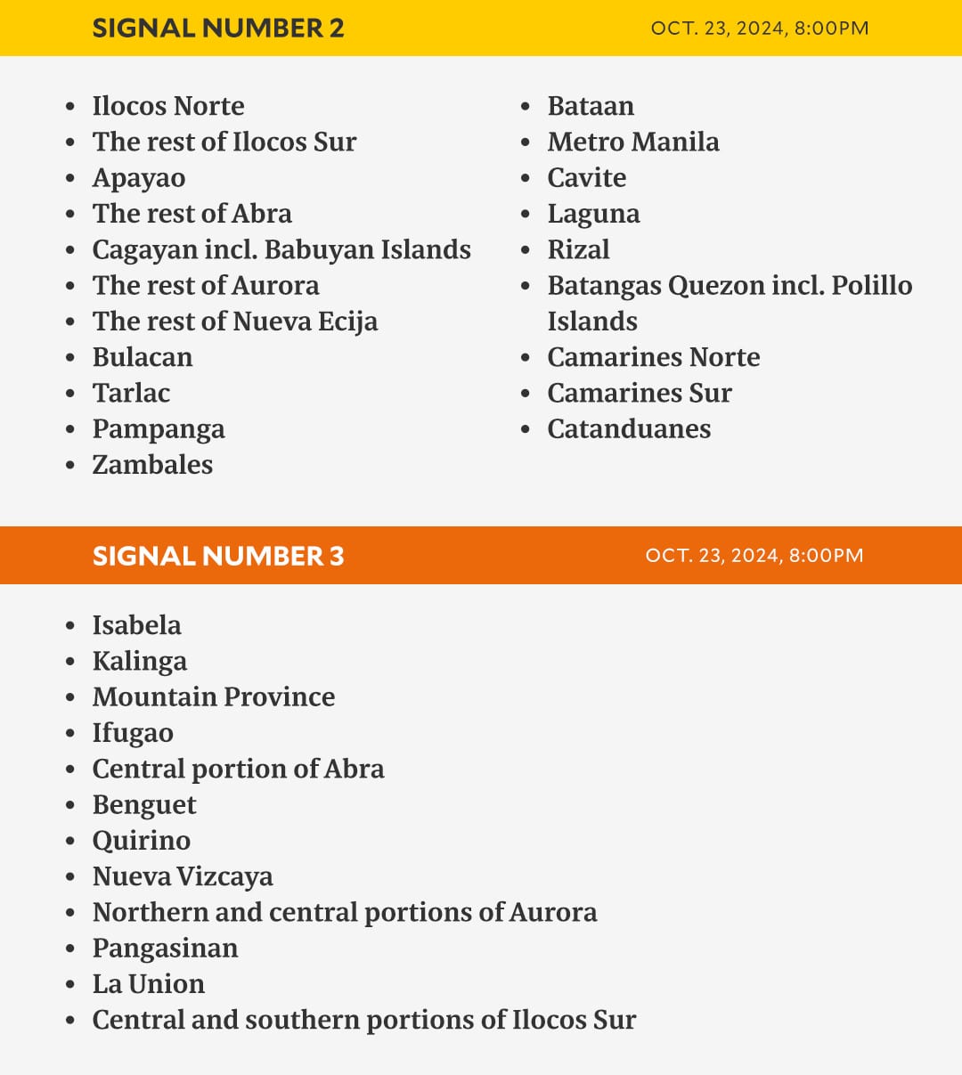
Pagasa added that Tropical Cyclone Wind Signal number 3 is still up over 12 areas in Luzon.
GRAPHIC: Ed Lustan
Areas under Signal No. 3
- Isabela
- Kalinga
- Mountain Province
- Ifugao
- The central portion of Abra (Malibcong, Licuan-Baay, Sallapadan, Daguioman, Bucloc, Boliney, Tubo, Luba, Manabo, Bucay, Villaviciosa, Pilar, San Isidro, Peñarrubia)
- Benguet
- Quirino
- Nueva Vizcaya
- Northern and central portions of Aurora (Dilasag, Casiguran, Dinalungan, Dipaculao, Maria Aurora, Baler)
- The northern portion of Nueva Ecija (Carranglan, Lupao, San Jose City, Pantabangan), Pangasinan
- La Union
- The central and southern portions of Ilocos Sur (Cervantes, Quirino, Sigay, Suyo, Alilem, Sugpon, Tagudin, Santa Cruz, Salcedo, Gregorio del Pilar, San Emilio, Lidlidda, Burgos, San Esteban, Santiago, Banayoyo, Galimuyod, City of Candon, Santa Lucia, Nagbukel, Santa Maria, Narvacan)
Areas under Signal No. 2
- Ilocos Norte
- The rest of Ilocos Sur
- Apayao
- The rest of Abra
- Cagayan including Babuyan Islands
- The rest of Aurora
- The rest of Nueva Ecija
- Bulacan
- Tarlac
- Pampanga
- Zambales
- Bataan
- Metro Manila
- Cavite
- Laguna
- Rizal
- Batangas
- Quezon including Polillo Islands
- Camarines Norte
- Camarines Sur
- Catanduanes
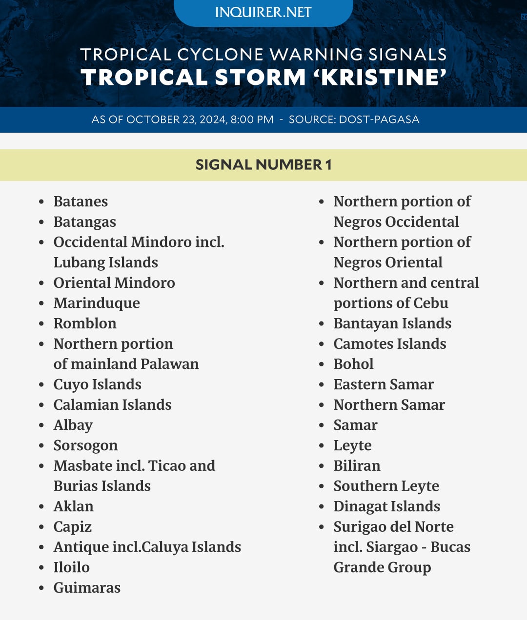
Areas under Signal No. 1
- Batanes
- Batangas
- Occidental Mindoro including Lubang Islands
- Oriental Mindoro
- Marinduque
- Romblon
- The northern portion of mainland Palawan (El Nido, Taytay, Araceli, San Vicente, Dumaran), Cuyo Islands
- Calamian Islands
- Albay
- Sorsogon
- Masbate including Ticao and Burias Islands
- Aklan
- Capiz
- Antique including Caluya Islands
- Iloilo
- Guimaras
- The northern portion of Negros Occidental (Pontevedra, La Castellana, Moises Padilla, Bago City, La Carlota City, Valladolid, Pulupandan, Bacolod City, San Enrique, Murcia, Silay City, City of Talisay, Enrique B. Magalona, Manapla, City of Victorias, Cadiz City, Sagay City, City of Escalante, Toboso, Calatrava, Salvador Benedicto, San Carlos City)
- The northern portion of Negros Oriental (Vallehermoso, Canlaon City, City of Guihulngan)
- The northern and central portions of Cebu (Alcantara, Argao, Dumanjug, Sibonga, Pinamungahan, Ronda, Liloan, Cebu City, Moalboal, Consolacion, Danao City, Borbon, Carmen, Daanbantayan, Tuburan, City of Bogo, Tabogon, City of Naga, Lapu-Lapu City, City of Carcar, Mandaue City, Catmon, Minglanilla, Toledo City, Cordova, Compostela, San Remigio, Balamban, Aloguinsan, San Fernando, Asturias, Barili, Medellin, Sogod, Tabuelan, City of Talisay) including Bantayan Islands
- Camotes Islands
- Bohol
- Eastern Samar
- Northern Samar
- Samar
- Leyte
- Biliran
- Southern Leyte
- Dinagat Islands
- Surigao del Norte including Siargao – Bucas Grande Group
Landfall, exit forecast
Pagasa said Kristine “is forecast to make landfall over Isabela tonight or tomorrow (24 October) early morning.”
It is expected to move westward or west northwestward over the West Philippine Sea and exit the Philippine area of responsibility on Friday (25 October) morning or afternoon.
GRAPHIC: Ed Lustan