
Kristine intensifies into a tropical storm early Tuesday, October 22, 2024, prompting the Philippine Atmospheric, Geophysical and Astronomical Services Administration to raise Tropical Cyclone Wind Signal No. 1 over 24 areas nationwide. Photo from Pagasa
MANILA, Philippines — Kristine intensified into a tropical storm early Tuesday, prompting the Philippine Atmospheric, Geophysical and Astronomical Services Administration to raise Tropical Cyclone Wind Signal No. 1 over 24 areas nationwide.
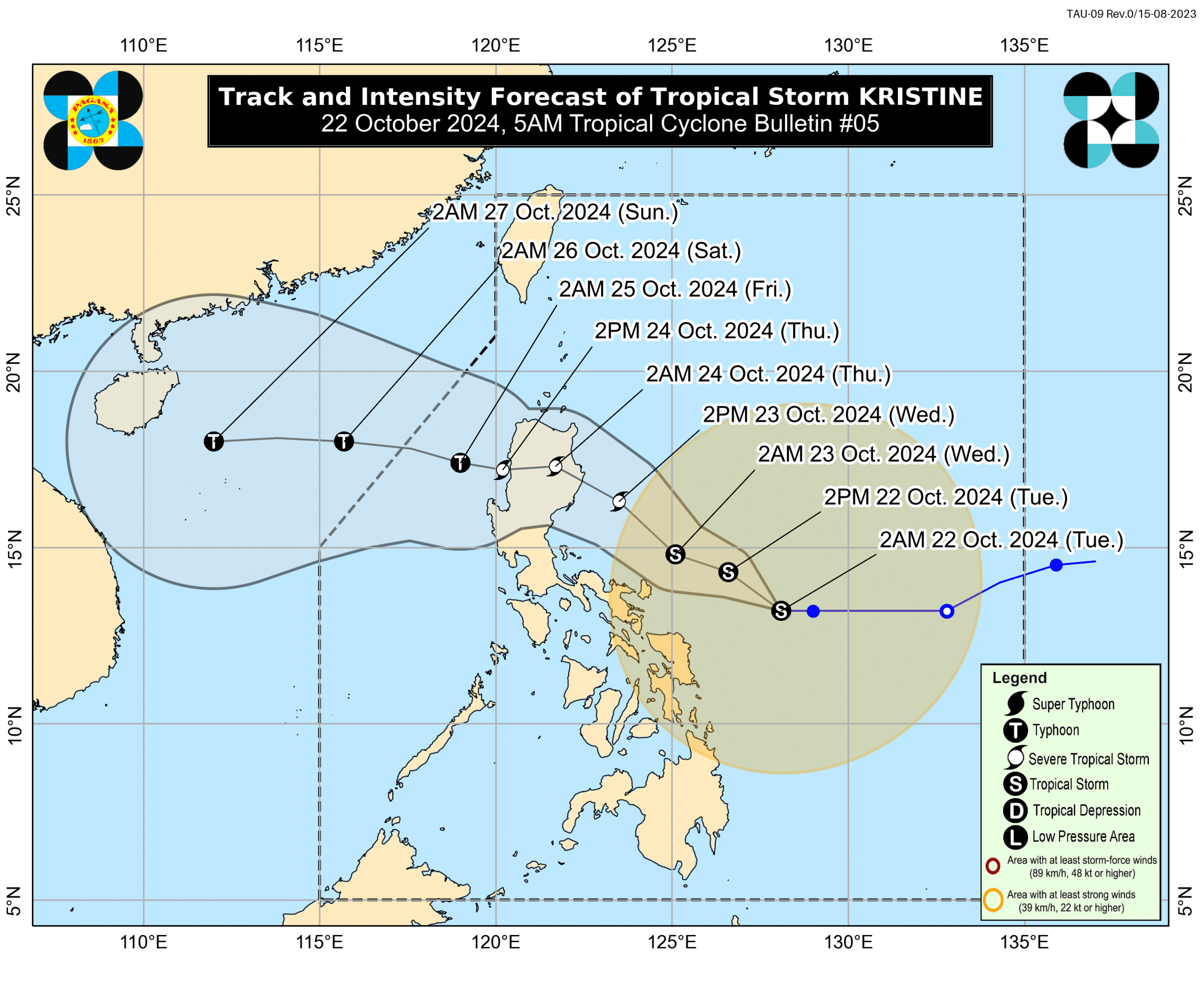
Based on its 5 a.m. cyclone bulletin, the center of Tropical Storm Kristine (international name: Trami) was last located 390 km east of Virac, Catanduanes, packing maximum sustained winds of 65 kph and gustiness of up to 80 kph. It was moving westward at 15 kph.
“Since this tropical cyclone is still over the Philippine Sea, rapid intensification is not ruled out given the favorable environmental conditions,” Pagasa noted.
READ: LIVE UPDATES: Tropical Depression Kristine
Hence, the state weather agency said Kristine may reach the severe tropical storm category by Wednesday, October 23, and make landfall over Isabela by Wednesday evening.
Pagasa said Kristine is projected to go “northwestward to west-northwestward until Thursday, October 24, before turning westward for the rest of the forecast period” and leave the Philippine area of responsibility by Friday evening, October 25.
Tropical Storm Kristine may further develop into a typhoon by Friday as it emerges over the West Philippine Sea, it added.
READ: OCD calls for ‘heightened preparedness’ vs Kristine
“The highest Wind Signal which may be hoisted during the occurrence of Kristine is still Wind Signal No. 4, considering the possibility of rapid intensification,” Pagasa said.
Below is the list of areas placed under Tropical Cyclone Wind Signal No. 1 as of 5 a.m., October 22:
Luzon
- The eastern and central portions of mainland Cagayan (Piat, Santo Nino, Camalaniugan, Tuao, Lal-Lo, Enrile, Gonzaga, Alcala, Amulung, Santa Teresita, Baggao, Buguey, Solana, Rizal, Santa Ana, Tuguegarao City, Gattaran, Peñablanca, Iguig, Lasam, Aparri, Allacapan)
- Isabela
- Quirino
- the southern portion of Nueva Vizcaya (Alfonso Castañeda)
- Aurora
- the eastern portion of Rizal (Tanay, Pililla, Jala-Jala)
- the eastern portion of Laguna (Majayjay, Magdalena, Pila, Santa Cruz, Pagsanjan, Luisiana, Cavinti, Lumban, Kalayaan, Paete, Pakil, Pangil, Siniloan, Famy, Santa Maria, Mabitac, Nagcarlan, Liliw)
- the northern and eastern portions of Quezon (Tagkawayan, Guinayangan, Buenavista, San Narciso, San Andres, General Nakar, Pitogo, San Francisco, Calauag, Pagbilao, Infanta, Lopez, Catanauan, Mulanay, Unisan, General Luna, Plaridel, Quezon, Alabat, Sampaloc, Padre Burgos, Macalelon, Mauban, Perez, Agdangan, Gumaca, Atimonan, Real, Lucena City, Lucban, City of Tayabas) including Polillo Islands
- Marinduque
- Romblon
- Camarines Norte
- Camarines Sur
- Catanduanes
- Albay
- Sorsogon
- Masbate, including Ticao Island and Burias Island
Visayas
- Eastern Samar
- Northern Samar
- Samar
- Leyte
- Biliran
- Southern Leyte
Mindanao
- Dinagat Islands
- Surigao del Norte, including Siargao – Bucas Grande Group

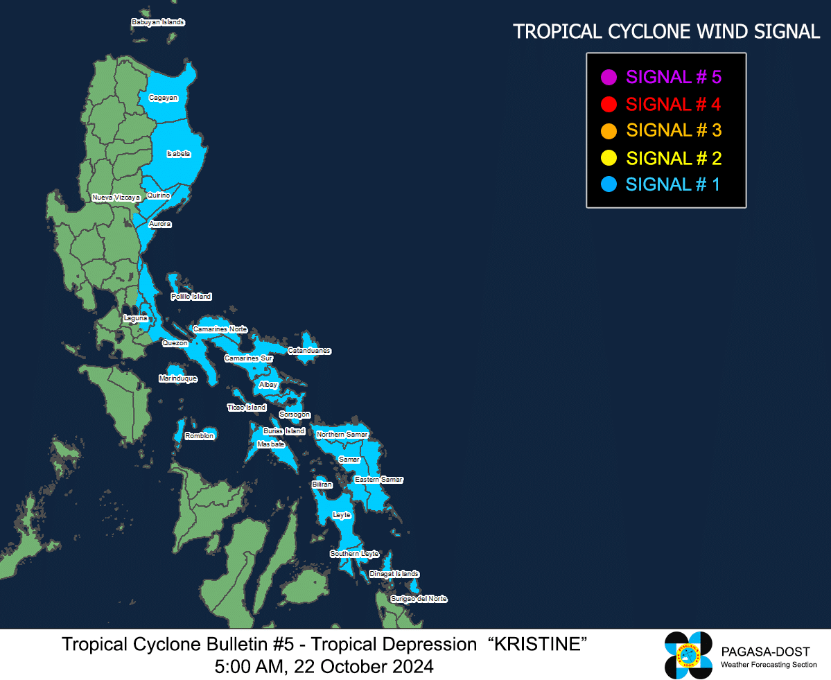
Photo from Pagasa
Kristine: Rough seas alert
Pagasa warned of hazards in the country’s coastal waters due to Tropical Storm Kristine.
It hoisted a gale alert over the eastern seaboard of Luzon, the southern seaboard of Southern Luzon, and the eastern seaboard of Visayas, noting that very rough seas with waves between 4.5 meters and 6.5 meters high anticipated in the coasts of Isabela; Bicol Region; Batanes; Cagayan; Aurora; northern, eastern, and western Northern Samar; Polillo Islands; northern Ilocos Norte; northern Biliran, and Northern Samar.
Pagasa said sea travel along these seaboards is risky for all types of ships and advised all mariners to remain in port or seek shelter or safe harbor as soon as possible until winds and waves subside if already at sea.
It also said that rough seas are expected over the coastal waters of western Ilocos Norte; Northern Luzon; Southern Leyte; Bohol; Camiguin; Dinagat Islands; Surigao del Norte; southern Palawan; Negros Occidental; Negros Oriental; Siquijor; eastern Davao Region; and eastern mainland Quezon as waves between 3 meters and 4 meters are expected in these seaboards amid Tropical Storm Kristine.
“Mariners of small seacrafts, including all types of motorbancas, are advised not to venture out to sea under these conditions, especially if inexperienced or operating ill-equipped vessels,” Pagasa said.
Waves of up to 2.5 meters, meanwhile, are possible in the remaining seaboards of the country. Pagasa noted that this means “moderate seas” and advised mariners using motorbancas and similarly-sized vessels “to take precautionary measures while venturing out to sea and, if possible, avoid navigation under these conditions.”