
(Photo courtesy of Pagasa)
MANILA, Philippines — Tropical Storm Enteng (international name: Yagi) maintained its strength as it moved over Isabela province on Monday evening, according to the state weather service.
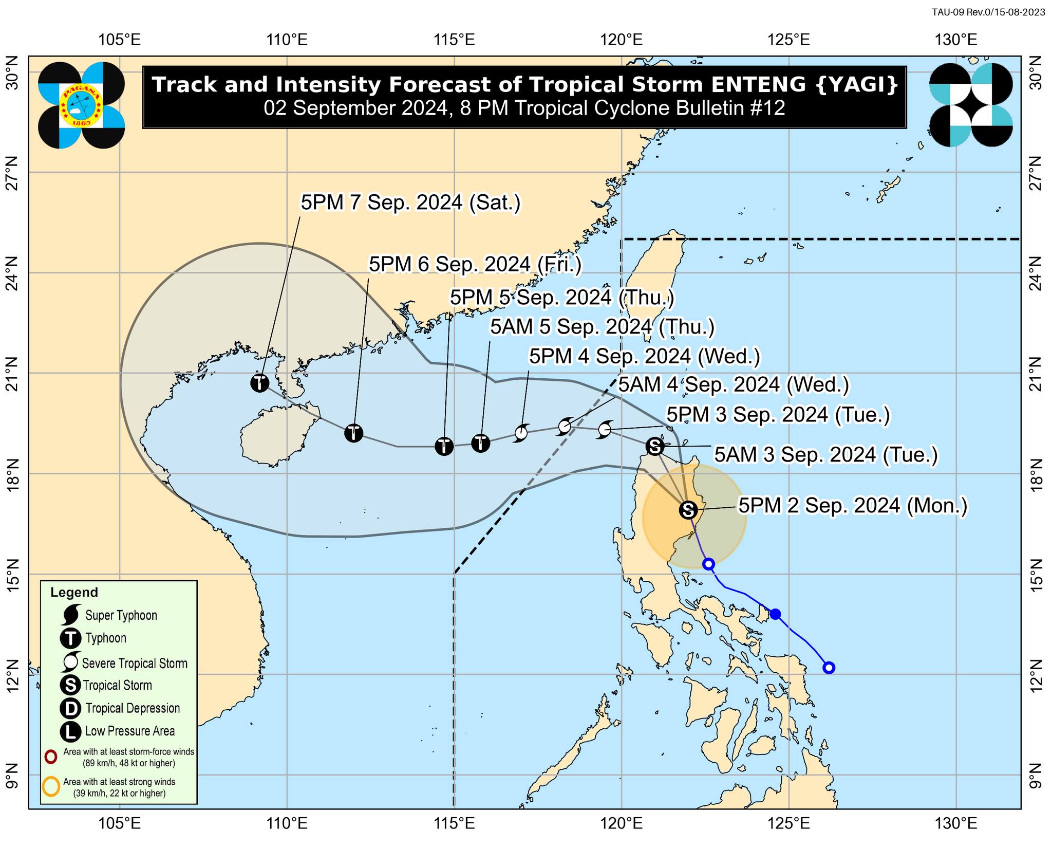
In its 8 p.m. update, the Philippine Atmospheric, Geophysical and Astronomical Services Administration (Pagasa) said Enteng slightly increased its speed at 25 kilometers per hour (kph), moving north-northwestward. It was carrying maximum sustained winds of 85 kph and gusts of up to 140 kph.
READ: Tropical Storm Enteng pounds Quirino after landfall over Aurora
“Enteng is forecast to continue moving north-northwestward or northward over Cagayan Valley or northern Cordillera Administrative Region before turning west-northwestward over the Babuyan Channel by tomorrow (3 September) morning,” Pagasa said.
“From tomorrow afternoon to Thursday, Enteng will move generally westward over the West Philippine Sea. On the track forecast, this tropical cyclone may exit the Philippine Area of Responsibility on Wednesday (4 September) morning or afternoon,” it added.
Due to the ongoing effects of the tropical storm, the following areas remain under wind signals:
Tropical Cyclone Wind Signal (TCWS) Number 2
- Ilocos Norte
- Apayao
- Kalinga
- The northern portion of Abra (Tineg, Lagayan, Lacub, Malibcong)
- The eastern portion of Mountain Province (Paracelis, Natonin)
- The eastern portion of Ifugao (Alfonso Lista, Aguinaldo)
- Cagayan including Babuyan Islands
- Isabela
- The northern portion of Quirino (Cabarroguis, Maddela, Aglipay, Diffun, Saguday)
- The northern portion of Aurora (Casiguran, Dilasag, Dinalungan)
TCWS No. 1
- Batanes
- Ilocos Sur
- La Union
- The eastern portion of Pangasinan (Rosales, Asingan, Binalonan, Sison, San Manuel, Santa Maria, Balungao, San Quintin, Tayug, Umingan, Natividad, San Nicolas)
- The rest of Abra
- The rest of Mountain Province
- The rest of Ifugao
- Benguet
- Nueva Vizcaya
- The rest of Quirino
- The central portion of Aurora (Maria Aurora, San Luis, Dipaculao, Baler)
- The northeastern portion of Nueva Ecija (Llanera, San Jose City, Carranglan, Pantabangan, Bongabon, Rizal, Lupao)
Meanwhile, the enhanced southwest monsoon will also bring strong to gale-force gusts over the following areas from September 2 to 3:
September 2
- Ilocos Region
- Aurora
- Zambales
- Bataan
- Bulacan
- Metro Manila
- Calabarzon
- Mimaropa
- Bicol Region
- Visayas
September 3
- Ilocos Region
- Nueva Vizcaya
- Quirino
- Zambales
- Bataan
- Aurora
- Bulacan
- Metro Manila
- Calabarzon
- Mimaropa
- Bicol Region
- Western Visayas
- Negros Island Region
- Northern Samar