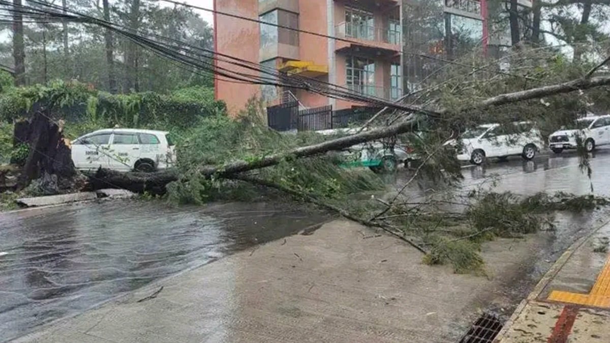
NATURE’S WRATH A fallen tree blocks a street in Baguio City following continuous rains dumped by Typhoon Carina on Tuesday. The heavy downpour also caused landslides in the city but no injuries were reported. —photo courtesy of Baguio PIO
TUGUEGARAO CITY, CAGAYAN, Philippines — Although Typhoon Carina (international name: Gaemi) was not forecast to make landfall while moving north-northwestward on Tuesday, it continued to enhance the “habagat“ (southwest monsoon), dumping heavy rain over the western side of Luzon.
The government weather bureau raised Tropical Cyclone Wind Signal No. 2 over parts of Batanes as continuous rain caused widespread flooding across northern and central Luzon, displacing hundreds of residents in coastal and low-lying areas, according to local disaster risk reduction management offices.
In Metro Manila, the National Disaster Risk Reduction and Management Council (NDRRMC) reported on Tuesday that at least seven people in Mindanao died from incidents related to the onslaught of Carina and Tropical Depression Butchoy, which hit the region last week.
The NDRRMC said four deaths were reported in Zamboanga Peninsula and one each in Northern Mindanao region, Davao region and Bangsamoro Autonomous Region in Muslim Mindanao.
In Cagayan province, at least 96 people sought shelter in evacuation centers after floods submerged their communities.
The Cagayan Provincial Disaster Risk Reduction and Management Office (PDRRMO) reported that as of 6 a.m. on Tuesday, the displaced families were staying in shelters in the towns of Peñablanca, Gonzaga and Santa Ana.
Several low-lying bridges in the province were also flooded, including Bagunot and Taytay-San Isidro bridges in Baggao; Natallag overflow bridge in Peñablanca; and Mapurao-Capanickian bridge in Allacapan.
Flooded roads include Tamucco-Balagan-Abariongan Ruar Road in Sto. Niño, and a farm-to-market road and bridge in Sitio Laoc, Gonzaga, Cagayan.
In Pampanga, heavy downpour since Monday night flooded 36 villages in the towns of Masantol, Macabebe, Minalin, Sto. Tomas and the City of San Fernando, according to PDRRMO Chief Angelina Blanco in a report on Tuesday noon.
Floodwaters reached up to .91 meter (3 feet) in the low-lying areas of Del Carmen and San Agustin villages in the City of San Fernando.
San Fernando Mayor Vilma Caluag reported that four families from Purok 7 in Barangay San Juan were evacuated to the village’s multipurpose center as the creek there overflowed on Monday night.
High tide
High tide and monsoon rains also caused water levels to rise as high as .97 meter (3.2 feet) in Masantol and Macabebe towns.
In Bulacan, a high tide of up to 1.49 meter (4.92 feet) on Monday caused floods in the coastal towns of Hagonoy and Bulakan, as well as low-lying areas in the City of Malolos, including Guiguinto.
At least 30 families from Sitio Libis in Bulakan were evacuated to Taliptip Elementary School around noon after high tide inundated their community, according to Bulacan PDRRMO.
It said the weeklong high tide began on July 19 at 1.28 meter (4.2 feet) and is expected to recede to .88 meter (2.89 feet) by Saturday.
Rains over the past several weeks, including those from Carina since Monday, prevented the further depletion of the volume of Angat Dam in Bulacan.
As of Tuesday, the dam’s elevation was recorded at 177.55 meters above sea level (masl), just over 2 meters below the minimum operating level of 180 masl.
Swollen rivers
In Zambales province, water level in Sta. Fe River in San Marcelino town continued to rise due to heavy rains.
Although the water level remains within normal limits, the local Disaster Risk Reduction Management Office (DRRMO) continues its sandbagging efforts as a precaution.
In Olongapo City, a warning on the rising water level in a river traversing Barangay Kalaklan was issued at 1:19 p.m. on Tuesday.
The continuous rains also triggered flooding in at least two villages in Juban, Sorsogon, on Tuesday. Some classrooms being prepared for the opening of classes were also hit by floods.
Class, work suspension
Due to Carina’s onslaught, classes and government work were suspended in Cavite province, Cavite City and Baguio City.
The strong rains caused landslides in Baguio, affecting residential areas at Purok 8 in Barangay Asin Road and Barangay Gabriela Silang.
A landslide also hit Kennon Road at Camp 4 in Tuba, Benguet, damaging and trapping several vehicles going to and leaving Baguio on Tuesday.
In Quezon province, the Philippine Coast Guard suspended sea travel on Tuesday for all vessels plying Lamon Bay facing the Pacific Ocean in Mauban town.
According to the Philippine Atmospheric, Geophysical and Astronomical Services Administration, Carina slightly intensified as it packed maximum sustained winds of 140 kilometers per hour near the center with gustiness of up to 170 km/h.
The weather bureau said the typhoon was spotted at 320 km east of Basco, Batanes before noon on Tuesday.
Signal No. 1 remained hoisted over the rest of Batanes, Cagayan including Babuyan Islands, eastern portion of Isabela, northern Apayao, northern Ilocos Norte, northern Aurora, Polillo Islands, Calaguas Island and northern Catanduanes. —with reports from Villamor Visaya Jr., Tonette T. Orejas, Carmela Reyes-Estrope, Joanna Rose Aglibot, Ma. April Mier-Manjares, Delfin T. Mallari Jr., Allan Macatuno and Nestor Corrales