


Tropical storm Aghon keeps its strength, while moving within the vicinity of Dolores, Quezon province, Pagasa says. (Photo courtesy of Pagasa)
MANILA, Philippines — Tropical storm Aghon has kept its strength as it moved within the vicinity of Dolores, Quezon on Sunday morning, according to the Philippine Atmospheric, Geophysical and Astronomical Services Administration (Pagasa).
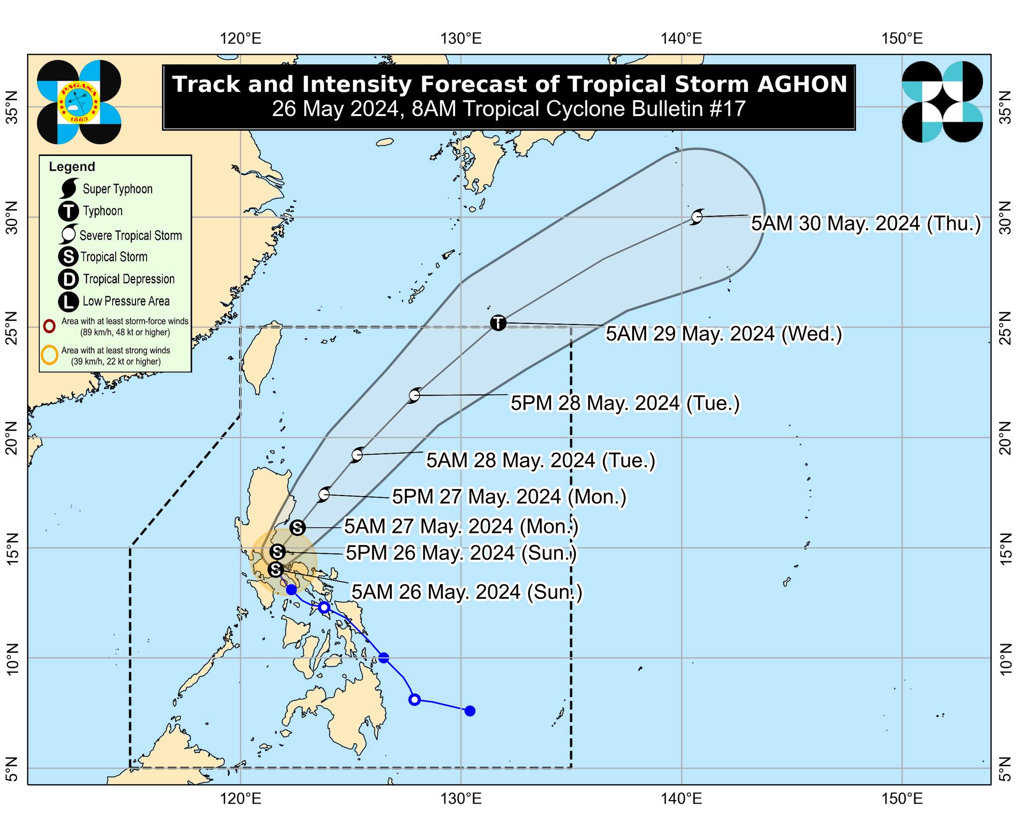
Based on its 8 a.m. bulletin, Pagasa reported that Aghon’s northwestward movement slightly increased at 15 kilometers per hour (kph) with maximum sustained winds of 65 kph and gusts of up to 110 kph.

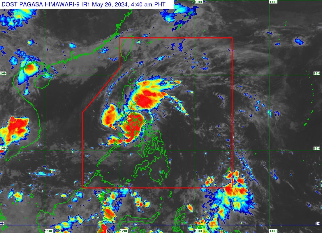
Tropical storm Aghon on Sunday morning, May 26, 2024 (Satellite image from Pagasa)
READ: Aghon develops into tropical storm, signal no. 2 raised in Quezon areas
It added that wind signals remain hoisted in the following areas:
Tropical Cyclone Wind Signal (TCWS) No. 2
The northern and central portions of Quezon (Alabat, Perez, Quezon, Gumaca, Lopez, Macalelon, General Luna, Unisan, Pitogo, Plaridel, Agdangan, Padre Burgos, Atimonan, Mauban, Real, General Nakar, Infanta, Sampaloc, Pagbilao, Calauag, Lucban, City of Tayabas, Lucena City, Tiaong, Candelaria, Sariaya, Dolores, San Antonio) including Polillo Islands and Laguna)
The eastern portion of Rizal (Jala-Jala, Pililla, Tanay)
The eastern portion of Batangas (City of Tanauan, San Jose, Lipa City, Mataasnakahoy, Balete, Malvar, Santo Tomas, Cuenca, San Pascual, Batangas City, Ibaan, Padre Garcia, Rosario, San Juan, Taysan, Lobo)
TCWS No. 1
The southeastern portion of Isabela (Palanan, Dinapigue)
The southern portion of Quirino (Maddela, Nagtipunan)
The southern portion of Nueva Vizcaya (Alfonso Castaneda)
The eastern and southern portions of Nueva Ecija (General Tinio, Gabaldon, Bongabon, Pantabangan, Rizal, General Mamerto Natividad, Laur, Palayan City, Peñaranda, San Leonardo, City of Gapan, Cabanatuan City, Santa Rosa, San Isidro, Cabiao, San Antonio, Jaen)
Aurora
The eastern portion of Pampanga (Candaba, San Luis, San Simon, Apalit, Santa Ana, Arayat)
Bulacan
Metro Manila
The rest of Quezon
The rest of Rizal
Cavite
The rest of Batangas
The northern portion of Oriental Mindoro (Pinamalayan, Pola, Naujan, Victoria, Socorro, City of Calapan, Bansud, Gloria, Baco, San Teodoro, Puerto Galera, Bongabong, Roxas)
Marinduque
Romblon
Camarines Norte
Camarines Sur
The northern portion of Albay (Tiwi, Polangui, Malinao, Libon, Oas, City of Ligao)
Burias Island
The state weather bureau said in the next 12 hours, the tropical storm will move across the landmass of Calabarzon and Polillo Islands.
It is forecast to arrive within the waters off the east coast of Quezon or Aurora by this evening or Monday morning.
“During this period, Aghon will likely remain as a tropical storm although weakening into a tropical depression while over mainland Calabarzon is not ruled out due to land interaction,” it added.
It may likely intensify into the severe tropical storm category by Tuesday and typhoon category inside the Philippine Area of Responsibility — far from the country’s landmass, Pagasa said.
“On the track forecast, Aghon may exit the PAR region on Wednesday,” the state weather service further reported.