Know the latest on Tropical Depression Kabayan through our LIVE UPDATES

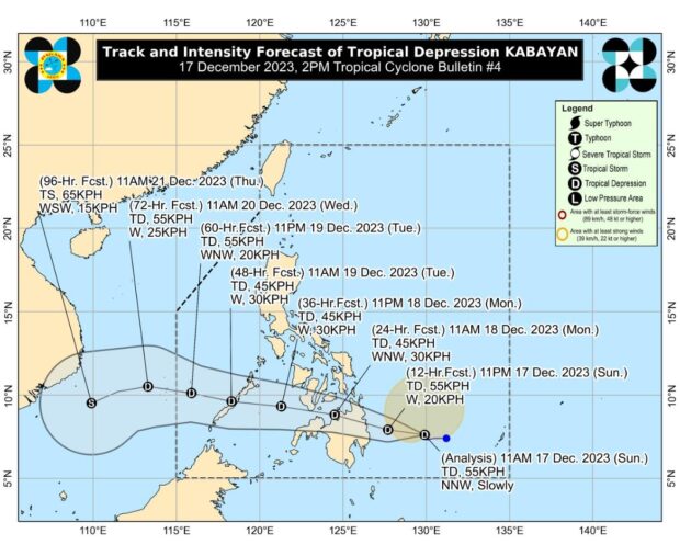
Image from DOST / Pagasa
MANILA, Philippines — Tropical depression Kabayan has maintained its strength as it slowly moves northwestward over the Philippine Sea, the Philippine Atmospheric, Geophysical and Astronomical Administration (Pagasa) said on Sunday afternoon.
Citing Pagasa’s 2 p.m. bulletin, Pagasa said Kabayan was last spotted 440 kilometers (km) east of Davao City with maximum sustained winds of 55 km per hour (kph) and gusts of up to 70 kph.
According to the state weather bureau, the tropical depression, along with the shear line, may bring heavy rainfall over the eastern portion of Southern Luzon within the day and the eastern portion of Luzon on Monday.
Based on Pagasa’s heavy rainfall outlook, the effects of Kabayan will be experienced in the following areas:
Sunday to Monday afternoon
- 100-200 millimeters (mm): Surigao del Sur, Surigao del Norte, Dinagat Islands, and Southern Leyte
- 50-100 mm: Eastern Visayas, Davao Region, Northern Mindanao, and the rest of Caraga
Monday afternoon to Tuesday afternoon
- 100-200 mm: Surigao del Sur, Surigao del Norte, Dinagat Islands, and Southern Leyte
- 50-100 mm: Eastern Visayas, Central Visayas, Northern Mindanao, and the rest of Caraga
Meanwhile, the surge of the northeast monsoon is expected to bring gusty conditions in Batanes, Babuyan Islands, Ilocos Norte, Ilocos Sur, Aurora, Bataan, Bulacan, Rizal, Quezon, Lubang Island, Marinduque, Cuyo Islands, Bicol Region, Visayas, the northern and eastern portion of mainland Cagayan, the eastern parts of Isabela and Nueva Ecija, and portions of Cordillera Administrative Region, Zambales, Pampanga, Cavite, Mindoro provinces until Monday afternoon.
READ: LPA east of Surigao del Sur now Tropical Depression Kabayan – Pagasa
Pagasa added that a gale warning was also raised over the seaboards of Northern Luzon, Eastern Visayas, and Eastern Mindanao.
Earlier, the state weather service reported that Kabayan is forecast to weaken and land along the coast of Surigao del Sur or Davao Oriental tonight or tomorrow morning.