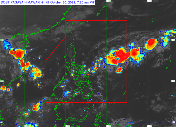
Weather satellite image from Pagasa
MANILA, Philippines — The low pressure area (LPA) off Eastern Visayas is seen to bring cloudy skies and rains in at least three regions of the country in the next few days, the state weather bureau said Monday.
According to state weather agency specialist Obet Badrina, the LPA is located inside the Philippine area of responsibility some 995 kilometers east of Visayas as of 3:00 a.m.
READ: Pagasa: Cloudy skies, rains may prevail over PH from Oct 30-Nov 3
Based on the observation of the Philippine Atmospheric, Geophysical and Astronomical Services Administration (Pagasa), this LPA so far has a small chance of developing into a typhoon.
“Sa ngayon ho, base sa ating latest na mga datos, maliit pa ang tiyansa na ito ay maging bagyo pero inaasahan natin na ito ay kumilos sa bahagi ng Visayas at Bicol Region itong LPA na ito,” Badrina said in an early morning public weather forecast.
(Right now, based on our latest data, there is little chance that this will become a typhoon, but we expect that this LPA will move in the Visayas and Bicol Region.)
READ: Pagasa: Northeast monsoon, localized thunderstorms, trough of LPA affecting PH
“Kaya inaasahan natin sa mga susunod na araw ay posible na magdala ng pag-ulan itong LPA partikular na sa Visayas at Southern Luzon,” he added.
(So we expect that in the next few days it is possible that this LPA will bring rain especially in the Visayas and Southern Luzon.)
The LPA is also predicted to bring overcast skies and rains in Metro Manila, Calabarzon (Cavite, Laguna, Batangas, Rizal and Quezon), and Mimaropa (Occidental Mindoro, Oriental Mindoro, Marinduque, Romblon, Palawan).
READ: Pagasa: Cloudy skies, isolated rains expected for most of PH
“Bandang Miyerkules o Huwebes, ay maging maulap din ang kalangitan na may kasamang pag-ulan pati ho dito sa bahagi ng Kamaynilaan at Calabarzon at Mimaropa areas,” Badrina further said.
(Around Wednesday or Thursday, the sky will also be cloudy with rain in Metro Manila and Calabarzon and Mimaropa areas.)