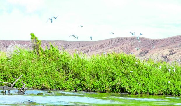
IN FLIGHT Wild birds fly above the new green landscape on Taal Volcano Island in this photo taken on Oct. 10, over three years after the volcano erupted in January 2020. —DEPARTMENT OF ENVIRONMENT AND NATURAL RESOURCES-CALABARZON PHOTO
LUCENA CITY—Despite its continued emission of toxic volcanic sulfur dioxide (SO2) gas, Taal Volcano in Batangas province is slowly reverting to its original state as a natural environmental wonder after its latest eruption in 2020, according to the Department of Environment and Natural Resources (DENR).
While the “complete healing” of Taal Volcano will still require more time, there were already signs of vegetation on the “Pulo,” the local name for the Taal Volcano Island, that was made barren by the volcano’s eruption in January 2020, according to the DENR in Calabarzon (Cavite, Laguna, Batangas, Rizal and Quezon).
In a report on Wednesday, the agency said their personnel recently conducted patrol and monitoring on a more than 9-kilometer stretch of the Taal Volcano Protected Landscape (TVPL) in the villages of Alas-as and Pulang Bato of San Nicolas town. The two villages are located on Pulo, which sits in the middle of Taal Lake. The DENR team was able “to witness the regaining beauty of Taal Volcano,” the agency said.
READ: Taal Volcano update: 3 quakes in 24 hours; Alert Level 1 stays
“Lush green grass covered the lawn at the foot of Taal Volcano, contemplating the grayish ridges that created a neutral-botanical color landscape,” the DENR-Calabarzon said.
The DENR-Calabarzon reported the presence of several water birds, including the grey heron (Ardea cinerea), black-crowned night heron (Nycticorax nycticorax), purple heron (Ardea purpurea), little egret (Egretta garzetta), crow (Corvus), brahminy kite (Haliastur indus) and plover (Charadrius), hovering over the island.
It said the observed regrowth of vegetation and the presence of wildlife in a span of three years was “undeniably a good sign of new life within the island.”
Altered landscape
On Jan. 12, 2020, Taal Volcano erupted, 43 years after its last major eruption in 1977.
The eruption altered the landscape of Pulo and displaced more than 5,000 people who, for generations, called it home.It was also “harmful, if not fatal, to the diverse plants, animals and ecosystems that can be found within the Pulo,” according to the DENR-Biodiversity Management Bureau (BMB).
The TVPL, which was declared a protected area in 1996, covers an area of 62,292.16 hectares, encompassing the Pulo, Taal Lake and 37 tributaries of the 13 towns and three cities in Batangas that surround the volcano.
“Various bird and fish species consider the TVPL their home. Fifty-two migratory and endemic marine faunal species are present in Taal Lake, according to a 2018 study,” the DENR-BMB said on its website.
The most popular and economically important is “sardinella tawilis,” or locally known as “tawilis,” which is endemic in Taal Lake.
Vog
“The [2020] eruption caused the protected area to be coated with thick layers of ash that had wiped out its vegetation, disrupted its ecological processes and drastically turned the same into a desert-like island,” the DENR said in the report.
The thick ashfall that spread as far as Metro Manila destroyed the vegetation on the island and rendered land and water bodies unproductive.
Since then, Taal, one of the country’s most active volcanoes, has had varying degrees of phreatic or steam-driven eruptions.
The Philippine Institute of Volcanology and Seismology (Phivolcs) maintained the alert level 1 status of the Taal Volcano, which means that phreatic eruptions, volcanic earthquakes, thin ashfalls and hazardous gas emissions may occur.
The Phivolcs has also cautioned the public against going to the Pulo and prohibits aircraft from flying near the crater.
The volcano has continued its emission of volcanic smog, or vog, since last month. Vog is composed of SO2 gas and can irritate the eyes, nose and throat. Notably, people with respiratory conditions—young and old—and pregnant women are at greater risk.
On Oct. 12, Taal Volcano spewed a total of 9,762 metric tons of SO2 gas, the highest recorded emission of sulfur dioxide for the year, according to Phivolcs.