Tourism gem rises out of Bohol quake ruins
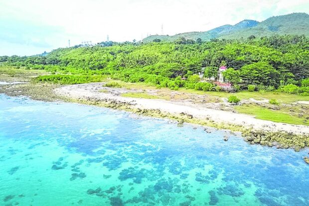
ALTERED LANDSCAPE | This coastal zone in Maribojoc, Bohol, has been elevated after a strong earthquake struck the province on Oct. 15, 2013. The Department of Environment and Natural Resources has declared the place a geological monument. (Photo courtesy of EDELIZA V. MACALANDAG / Contributor)
TAGBILARAN CITY, Bohol, Philippines — Bohol may be the perfect example of the proverbial remark, “When life gives you lemons, make lemonade.”
The province, whose main industry is tourism, has turned tragedy into an opportunity by promoting the geological sites that formed after a magnitude 7.2 earthquake brought Bohol to its knees on Oct. 15, 2013.
It is now advertising a “Geosciences Tour” that allows tourists to see changes on Bohol’s landscape following the earthquake. The features include sinkholes, hectares of dry land in Maribojoc town that rose from the shoreline and the so-called “Great Wall of Bohol” in Inabanga town.
Last May, Bohol’s tourism campaign included the first and only geopark in the Philippines with a goal to attract a million tourists.
It capitalizes the statement issued by United Nations Educational, Scientific and Cultural Organization (Unesco), declaring Bohol as the country’s first Unesco Global Geopark following the new landscapes and geological sites that emerged after the earthquake.
Article continues after this advertisementGov. Erico Aristotle Aumentado said the Unesco’s title on Bohol would help enhance the economic and tourism value of the province and boost environmental protection efforts.
Article continues after this advertisement“We all have the responsibility to protect our island as a Global Geopark as this is one of the things we can be proud of,” said Aumentado.
At 8:12 a.m. of Oct. 15, 2013, a magnitude 7.2 earthquake shook the island-province of Bohol for 33 seconds. Yet, it managed to kill 222 people, injure more than 800 people and displace 95,884 families (465,146 individuals).
The earthquake destroyed 8,083 houses and damaged 42,771 others in 43 towns and one city out of 47 towns and the capital Tagbilaran City.
Of the 43 towns, 17 were badly hit. These were Antequera, Balilihan, Buenavista, Calape, Carmen, Catigbian, Clarin, Corella, Cortes, Danao, Inabanga, Loon, Maribojoc, Sagbayan, San Isidro, Sevilla and Tubigon.
The earthquake toppled centuries-old churches that Bohol was known for, destroyed government infrastructure and facilities, as well as homes, displacing thousands of people.
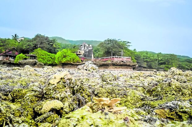
This is Punta Cruz in the coastal zone in Maribojoc, Bohol. (Photo courtesy of EDELIZA V. MACALANDAG / Contributor)
Unique occurrence
But with the widespread destruction came creation of new landforms as what happened in Bohol was described by scientists as a rare phenomenon.
According to the Philippine Institute of Volcanology and Seismology (Phivolcs), the 2013 earthquake was the first recorded reverse thrust, fault-type earthquake to occur inland in the Philippines since most of its kind usually happen offshore.
A thrust fault earthquake occurs when the ground movement goes up or vertically rather than horizontally.
This explains why some areas in Bohol, such as in Loon and Maribojoc towns, experienced land uplifting.
In Inabanga town for instance, what used to be a slopping area in Barangay Anonang is now a 5-meter high rocky wall that is about 3-kilometer long after a continuous ground rupture pushed the ground up, creating what is now the “Great Wall of Bohol.”
The earthquake also resulted in the emergence of several sinkholes.
The Mines and Geosciences Bureau recorded 1,333 sinkholes in the province, including the Catigbian Karst Window, a 60-foot deep karst site in Catigbian town.
The Department of Environment and Natural Resources declared as geological monument the 1.7 km of uplifted coastal areas in Loon and Maribojoc.
The Loon-Maribojoc coastal areas were pushed 1.5 km upwards that what was once part of the sea bottom and underwater reef were now above sea level, pushing back the coastline by about 50 meters and birthing new land along 8-km coastline in western Bohol.
It is now teeming with sea purslane, a creeping succulent seagrass plant of the family Aizoaceae, that covers the land with a mat of red and orange during sunny days and a luxurious green during rainy days.
Locals call the area “Coral Garden,” which has since become a popular destination for tourists and residents alike.
These new landforms are part of what the Bohol tourism office has packaged into the geosciences tour.
But these new sights are not the only ones that piqued the curiosity of tourists into coming to Bohol.
“The effects of the earthquake has made Bohol more well known to the world,” said Flor Lawangon from Wow Bohol Travel and Tours, a travel agency based in Tagbilaran.
“They came to Bohol to see the ruins. [But] they would [also] like to know [about] the rehabilitation,” she said.
Lawangon said that even if a decade had passed, some first-time guests still liked to visit the affected areas to see what these looked like now.
Tourists, for instance, were curious about the effects of the earthquake on the famous Chocolate Hills, the province’s main tourism draw, which were not also spared.
Some hills were ripped although these were far from the popular viewing areas in Carmen town.
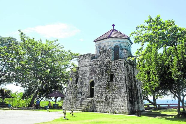
WATCHTOWER | The Fort of Saint Vincent Ferrer, commonly known as Punta Cruz Watchtower,
sustained major damage when a magnitude 7.2 earthquake struck Bohol and parts of Central
Visayas in 2013. The watchtower, constructed in 1796 to help community sentinels watch for
approaching invaders, has been rebuilt. (Photo courtesy of JHELMAR JALA and CHARLES PESQUIRA)
‘Faith tourism’
Aside from the geosciences tour, Bohol also has what they call “faith tourism” which showcases, among others, the restored centuries-old churches.
At least 24 churches — 10 of these were national heritage — were either destroyed or damaged.
Four years after the quake struck, Our Lady of Immaculate Conception parish church, popularly known as Baclayon Church, was the first to rise from the rubble.
After eight years, all of the affected churches have either been restored or rehabilitated. These include the Sto. Niño Parish Church in Cortes (2019), Señora de la Luz in Loon (2021), St. Peter the Apostle Church in Loboc (2021) and Parroquia de la Santa Cruz in Maribojoc (2021).
Some tourist attractions in the province have also been rehabilitated.
One of these is the Inang-angan stairway, a coral stone stairway that is made of five flights and 212 steps, which has been declared a national cultural treasure by the National Museum.
The stairway, which was damaged during the quake, was made of limestone blocks and was constructed from 1847 to 1849 by the Boholanos to allow more efficient trading of services.
The Punta Cruz Watchtower in Maribojoc, which was reduced to rubble, has also been restored. It now stands tall over the uplifted coastal areas.
Recovery
With all the added “attractions” in Bohol, it is not surprising that tourism in the province has started to pick up after suffering a slump in 2020 and 2021 due to the COVID-19 pandemic which prompted the government to impose health protocols and restrict travels.
Department of Tourism (DOT) records showed that in 2022, tourist arrivals in Bohol reached 535,803, thrice more than 2021’s 177,341.
While the figures were still low compared to the prepandemic levels, these were higher compared to the pre-earthquake level.
Based on DOT records, tourist arrivals in 2013 reached 389,767 but went up to 455,155 in 2014; 602,257 in 2015; 1,000,186 in 2016; 1,131,065 in 2017; 1,149,129 in 2018; and 1,581,904 in 2019.
The figures indicated high interest in Bohol after the earthquake. And the interest will likely not wane with the Bohol provincial government capitalizing on these geological landforms.
While praising Bohol’s unique geology, Teresito Bacolcol, Phivolcs director, hopes that local governments will also use this as a reminder to increase their preparations in the event of another major earthquake.
He stressed that the aftermath of 2013 should serve as a reminder to build safer, earthquake-resistant infrastructures and implement robust risk reduction measures.
“In the passage of time, the impact of past disasters is easily forgotten. We must not be complacent of the lessons of Oct. 15, 2013,” Bacolcol said.