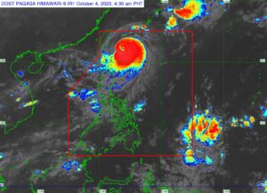
MANILA, Philippines — Typhoon Jenny (international name: Koinu) maintained its weakening trend but Itbayat, Batanes remains under Tropical Cyclone Wind Signal Number 3, the state weather bureau said on Wednesday.
Meanwhile, the rest of Batanes and the northern portion of Babuyan Islands, including Calayan Islands, are still under Signal Number 2.
According to the latest bulletin of Philippine Atmospheric, Geophysical and Astronomical Services Administration (Pagasa), the following areas are listed under Signal Number 1:
– The rest of Batanes Islands
– Northern portion of mainland Cagayan (Santa Ana, Gonzaga, Buguey, Santa Teresita, Lal-Lo, Camalaniugan, Pamplona, Claveria, Abulug, Allacapan, Sanchez-Mira, Santa Praxedes, Luna, Gatgawayan)
– Northern portion of Apayao (Calanasan, Pudtol, Luna, Santa Marcela, Flora)
– Northern portion of Ilocos Norte (Piddig, Bangui, Vintar, Burgos, Pagudpud, Bacarra, Adams, Pasuquin, Carasi, Dumalneg, Laoag City)
“Sa mga lugar na ito ay inaasahan natin ang masungit na panahon. Magdadala po ito [Jenny] ng malalakas na hangin at posibleng malalakas na pag-ulan,” said Pagasa weather specialist Obet Badrina.
(In these areas, we expect rough weather. It [Jenny] will bring strong winds and possible heavy rains.)
Ibayong pag-iingat po lalo na sa mga kababayan natin dito sa may Batanes at Babuyan areas kung saan inaasahan natin na lalapit ang bagyo,” he added.
(Please take extra care, especially to our countrymen here in Batanes and Babuyan areas, where we expect the typhoon to approach.)
The center of the eye of Jenny was spotted 270 kilometers east northeast of Itbayat, Batanes as of 4 a.m.
The typhoon is carrying wind speeds of 150 kilometers per hour (kph) near the center and gustiness of up to 185 kph, weakening from Tuesday evening’s speed of 155 kph speeds and gustiness of 190 kph.
Jenny maintained its west-northwestward movement at 10 kph.
“Ngayong hapon ay patuloy niyang [Jenny] babaybayin at kikilos na ito patungo sa may bahagi ng Taiwan,” Badrina said.
(This afternoon, Jenny will continue to move towards a part of Taiwan.)
“Bukas po, araw ng Huwebes, ay posible itong mag landfall sa may southern part ng Taiwan at posible po by tomorrow afternoon to evening ay nasa labas na ito ng Philippine area of responsibility,” he added.
(Tomorrow, Thursday, it is possible to make landfall in the southern part of Taiwan and it is possible that by tomorrow afternoon to evening, it will be outside Philippine area of responsibility.)
However, Jenny will continue to enhance the southwest monsoon, locally known as habagat, which will bring occasional rains over the western section of Luzon in the next three days.
Badrina warned people who are residing in areas affected by Jenny and enhanced habagat to stay alert against possible flashfloods and landslides.
“‘Yung mga mabababang lugar posible pong bumaha doon. Sa mga lugar naman kung saan matarik ay posible naman magkaroon ng landslide, lalo na kung ilang araw nang umuulan,” he said.
(Those low-lying areas, these may be flooded. In steep areas, landslides are possible, especially if downpours have been ongoing for several days.)
Gale warning alert is still hoisted over Batanes, Cagayan including Babuyan Islands, Isabela, and Ilocos Norte.
APL
RELATED STORIES
