Typhoon Jenny intensifies again, to pass between southern Taiwan and Batanes
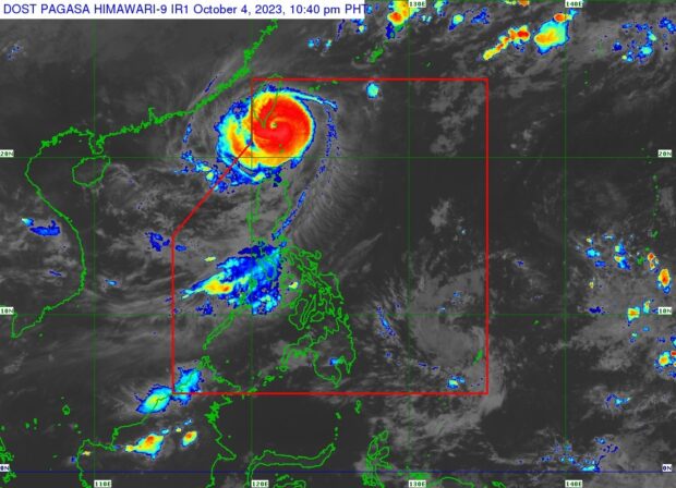
Pagasa’s latest satellite image shows Typhoon Jenny moving between the southern portion of Taiwan and the Batanes group of islands. Jenny intensified again as of Wednesday night, packing maximum sustained winds of 165 kph near the center, and gustiness of up to 205 kph. (Photo from DOST-Pagasa)
MANILA, Philippines — Typhoon Jenny intensified anew as it moves between the southern portion of Taiwan and the Batanes group of islands, the state weather bureau said on Wednesday night.
According to the Philippine Atmospheric, Geophysical and Astronomical Services Administration (Pagasa) bulletin as of 11:00 p.m., Jenny is now packing maximum sustained winds of 165 kilometers per hour (kph) near the center, and gustiness of up to 205 kph.
It was last located 125 kilometers north of Itbayat, Batanes, and is moving west at the speed of 15 kph.
Tropical Cyclone Wind Signal No. 3 has been raised over the entire Batanes; while the northern portion of Babuyan Islands are under Signal No. 2.
The following areas, on the other hand, have been placed under Tropical Cyclone Wind Signal No. 1:
- The rest of Babuyan Islands
- Northern portion of mainland Cagayan (Santa Ana, Gonzaga, Buguey, Santa Teresita, Lal-Lo, Camalaniugan, Pamplona, Claveria, Aparri, Ballesteros, Abulug, Allacapan, Sanchez-Mira, Santa Praxedes, Lasam, Gattaran)
northern portion of Apayao (Calanasan, Pudtol, Luna, Santa Marcela, Flora) - Northern portion of Ilocos Norte (Piddig, Bangui, Vintar, Burgos, Pagudpud, Bacarra, Adams, Pasuquin, Carasi, Dumalneg, Laoag City)
Pagasa expects Jenny to make landfall over the southern portion of Taiwan on Thursday morning before leaving the Philippine area of responsibility (PAR) between Thursday afternoon or evening.
Once outside PAR, the cyclone is to slowly continue its westward movement, over the Taiwan Strait and then towards southwestern China’s coastal waters.
Pagasa said Jenny will eventually weaken after passing the mountainous area of southern Taiwan, but it will still intensify the southwest monsoon or habagat, which will cause occasional rains over the western portion of Luzon in the coming days.
“Forecast rainfall are generally higher in elevated or mountainous areas. Under these conditions, flooding and rain-induced landslides are possible especially in areas that are highly or very highly susceptible to these hazards as identified in hazard maps and in localities that experienced considerable amounts of rainfall for the past several days,” Pagasa said.
“In addition, Jenny will continue to enhance the southwest monsoon and bring occasional rains over the western portions of Luzon in the next 3 days,” it added.
By Sunday, Jenny is expected to weaken into a tropical depression because of interaction with dry and cool air from the north.