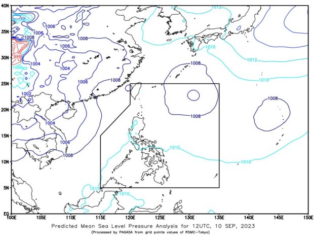
Pagasa says the LPA inside PAR was last monitored 895 kilometers (km) east northeast of extreme northern Luzon, while the one outside the country’s boundary was last seen 2,169 km east of central Luzon. (Photo courtesy of Pagasa)
MANILA, Philippines — The low-pressure areas (LPA) spotted inside and outside the Philippine area of responsibility (PAR) are not expected to develop into tropical cyclones, the state weather bureau said on Sunday.
According to the Philippine Atmospheric, Geophysical and Astronomical Services Administration (Pagasa), the LPA inside PAR was last monitored 895 kilometers (km) east northeast of extreme northern Luzon, while the one outside the country’s boundary was last seen 2,169 km east of central Luzon.
“Base sa ating analysis mababa ang tsansa nitong (LPA inside PAR) maging bagyo sa susunod na 24 hours at dahil malayo pa ito sa ating kalupaan wala itong direct effect [sa bansa],” weather specialist Benison Estareja said in an afternoon forecast.
(Based on our analysis, the LPA inside the country’s boundary has a low chance of becoming a tropical cyclone in the next 24 hours and does not directly affect our country since it remains far from the landmass.)
Estareja added that the LPA’s trough or extension would mainly affect and bring scattered rain showers in Batanes and Babuyan Islands. It is expected to remain stationary and move closer to northern Luzon by Tuesday (September 12).
Meanwhile, the LPA outside PAR would enhance the southwest monsoon, locally known as habagat, and affect most parts of Mindanao. It is forecast to move northward over the next few days.
Although the LPA outside PAR is expected to enhance habagat, Pagasa said no gale warning is currently raised in the country’s seaboards.


