
MANILA, Philippines — The state weather bureau said another weather disturbance – a cloud cluster – was seen east of the country outside the Philippine area of responsibility (PAR), adding that it may develop into a tropical depression in the next two to three days.
Philippine Atmospheric, Geophysical and Astronomical Services Administration (Pagasa) weather specialist Benison Estareja disclosed this in a public forecast on Thursday evening.
“[May] namataan tayong cloud cluster dito sa malayong silangan ng ating bansa sa labas ng PAR malapit sa Guam. Possible itong mabuo into a low pressure area anytime at ma-develop into a tropical depression sa loob ng dalawa hanggang tatlong araw,” said Estareja.
(We have observed a cloud cluster here in the far east of our country outside the PAR near Guam. It may develop into a low pressure area anytime and further intensify into a tropical depression within two to three days.)
Estareja said the state weather bureau will continue to monitor this potential cyclone. He, however, did not specify if it may enter the Philippine boundary.
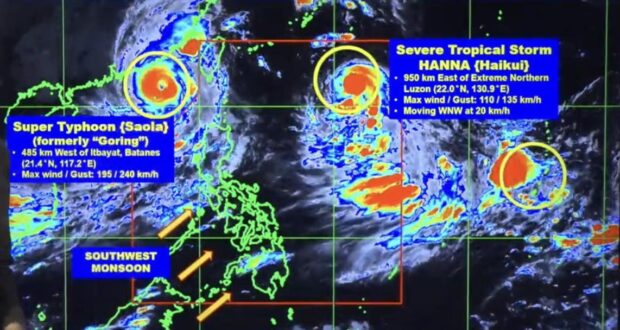
Meanwhile, the southwest monsoon, which is being enhanced by the Severe Tropical Storm Hanna (international name: Haikui) Super Typhoon Goring (international name: Saoloa), continues to affect the Philippines, particularly Luzon.