


Parts of Cagayan under Signal No. 4 due to Super Typhoon Egay; winds up to 184 kph possible
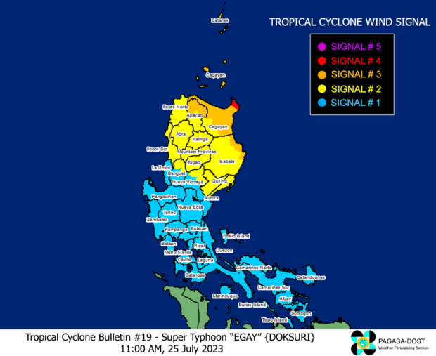
Photo from Pagasa
MANILA, Philippines — Tropical Cyclone Wind Signal (TCWS) No. 4 was raised on Tuesday morning over the northeastern portion of mainland Cagayan due to Super Typhoon Egay (international name: Doksuri).
In its latest cyclone bulletin, the Philippine Atmospheric, Geophysical and Astronomical Services Administration (Pagasa) explained that parts of Cagayan, being under TCWS No. 4, may experience typhoon-force winds ranging from 118 kilometers per hour (kph) to 184 kph within 12 hours.
The eye of Super Typhoon Egay was last located 270 kilometers east of Tugegarao City in Cagayan province, packing maximum sustained winds of 185 kph and gustiness of 230 kph, according to Pagasa.
Pagasa likewise mentioned the possibility of Egay making landfall over the northern portion of mainland Cagayan.
“It is forecast to make landfall or pass very close to Babuyan Islands-northeastern mainland Cagayan area between late evening today (Tuesday, July 25) and tomorrow morning,” Pagasa said.
“Slight northward or southward shift in this segment of the track (but within the forecast confidence cone) may result in a landfall or close approach over northern mainland Cagayan or Batanes,” it added.
Pagasa also raised cyclone wind signals over other areas along Egay’s path.
TCWS No. 3 was hoisted over the following areas:
- Babuyan Islands
- The northern and eastern portions of mainland Cagayan (Gonzaga, Peñablanca, Gattaran, Lal-Lo, Alcala, Santa Teresita, Buguey, Aparri, Camalaniugan, Ballesteros, Allacapan, Abulug, Claveria, Pamplona, Sanchez-Mira, Santa Praxedes, Lasam, Baggao, Amulung, Iguig)
- The northeastern portion of Isabela (Divilacan, Maconacon, Palanan)
- The northern portion of Apayao (Calanasan, Luna, Santa Marcela, Flora, Pudtol)
Here, winds greater than 89 kph or up to 117 kph may be expected for at least 18 hours.
Areas under TCWS No. 2 are as follows:
- Batanes
- The rest of mainland Cagayan
- The rest of Isabela
- Quirino
- The northern portion of Nueva Vizcaya (Kasibu, Quezon, Diadi, Bagabag, Ambaguio, Villaverde, Solano, Bayombong)
- The rest of Apayao
- Kalinga
- Abra
- Mountain Province
- Ifugao
- The northern portion of Benguet (Bakun, Mankayan, Buguias, Kabayan, Kibungan)
- Ilocos Norte
- Ilocos Sur
- The northern and central portion of Aurora (Dilasag, Casiguran, Dinalungan, Dipaculao)
These areas may anticipate winds greater than 62 kph or up to 88 kph for at least 24 hours.
Meanwhile, 25 areas have been placed under TCWS No. 1, where winds ranging from 39 kph to 61 kph or intermittent rains may be experieced within 36 hours:
- Metro Manila
- La Union
- Pangasinan
- The rest of Benguet
- The rest of Nueva Vizcaya
- The rest of Aurora
- Zambales
- Bataan
- Nueva Ecija
- Tarlac
- Pampanga
- Bulacan
- Rizal
- Laguna
- Cavite
- Batangas
- Quezon
- Marinduque
- Camarines Norte
- Camarines Sur
- Catanduanes
- Albay
- Sorsogon
- Burias Island
- Ticao Island
RELATED STORIES
11 regions feel impact of Egay
Typhoon Egay continues to intensify; Signal No. 3 up in 2 provinces


