Tropical Depression Egay almost stationary, possible super typhoon intensity by Tuesday
Source: DOST / Pagasa
MANILA, Philippines — Tropical Depression Egay’s movement over the Philippine Sea has slowed down, as the state weather bureau predicts that it may reach super typhoon intensity by Tuesday, July 25.
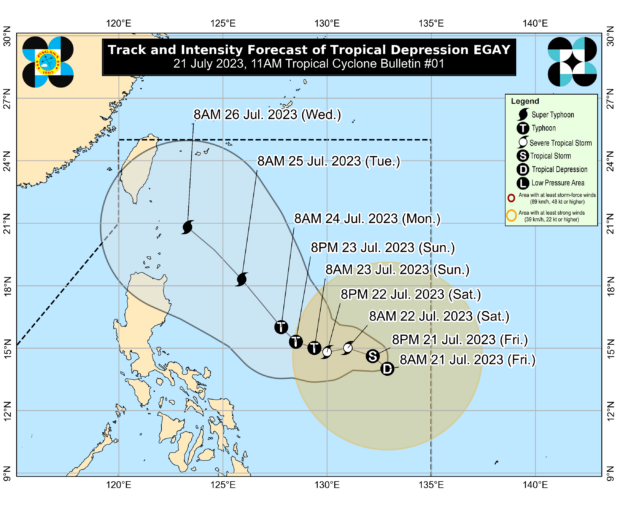
The latest weather bulletin from the Philippine Atmospheric, Geophysical and Astronomical Services Administration (Pagasa) showed that Egay was seen 825 kilometers east of Southeastern Luzon last 10 p.m. — moving just 10 kilometers since Pagasa’s previous 4 p.m. update.
Egay was also able to maintain its strength, packing maximum sustained winds of 55 kilometers per hour (kph) near the center, and gustiness of up to 70 kph.
Pagasa said that the disorganized nature of Egay’s circulation indicates that a landfall scenario, while unlikely, cannot be discounted.
“Egay is forecast to track generally west northwestward or westward tonight through Sunday before turning northwestward for the remainder of the forecast period,” Pagasa said.
Article continues after this advertisement“While the current track forecast shows a mainly offshore track, the forecast confidence cone indicates that a landfall scenario over the northern portion of Northern Luzon is not ruled out at this time. Owing to the fairly disorganized nature of Egay’s circulation, shifts in the track forecast are possible in succeeding bulletins,” it added.
Article continues after this advertisementPagasa is also expecting that Egay, because of its prolonged stay over bodies of water and its slow movement, will intensify further and reach super typhoon category on Tuesday, as it moves along extreme northern Luzon.
Egay is expected to intensify into a tropical storm by Saturday morning, when it moves to 795 kilometers east of Virac, Catanduanes. By Saturday night, it will already be a severe tropical storm, and during that time Egay would be 685 kilometers east of Virac.
By Sunday night, forecasts show that Egay would be a typhoon-category cyclone, and super typhoon by Tuesday, when it moves to around 370 kilometers of Calayan, Aurora.
No Tropical Cyclone Wind Signals have been raised as of now, but Pagasa said that the following areas can expect gusty conditions and rains due to the enhanced southwest monsoon or habagat:
- Friday night to Saturday: Western and southern portions of Visayas, the northern portions of Northern Mindanao and Caraga, and portions of Romblon and Palawan
- Sunday: Central and western portions of Visayas, the northern portions of Northern Mindanao and Caraga, and most of Mimaropa
- Monday: Mimaropa, Western Visayas, Central Visayas, the northern portions of Northern Mindanao and Caraga
“Considering these developments, the public and disaster risk reduction and management offices concerned are advised to take all necessary measures to protect life and property,” Pagasa said.
“Persons living in areas identified to be highly or very highly susceptible to these hazards are advised to follow evacuation and other instructions from local officials,” it added.
READ: Egay may become a super typhoon by Monday, threatening Sona