Dodong leaving faster but rains to persist in Luzon — Pagasa

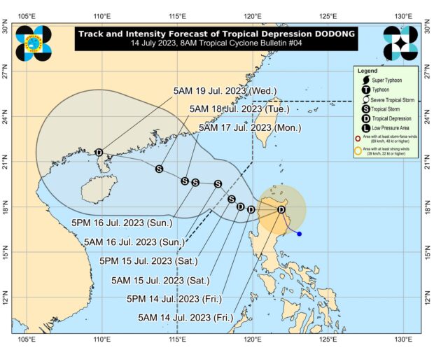
Tropical Depression Dodong’s track. Photo from Pagasa’s website
MANILA, Philippines — Tropical Depression Dodong’s speed has increased slightly as of Friday afternoon.
However, the state weather bureau reported rains will still prevail in various areas due to the southwest monsoon or habagat.
This means the cyclone is moving out of the Philippine area of responsibility faster and earlier.
It will exit between Saturday night and Sunday morning.
But downpours will still be experienced, especially over western parts of Luzon due to habagat.
Article continues after this advertisementLatest weather updates from Philippine Atmospheric, Geophysical and Astronomical Services Administration (Pagasa) showed as of 4:00 p.m., Dodong was over the coastal waters of Laoag, Ilocos Norte.
Article continues after this advertisementIt still packs maximum sustained winds of 45 kilometers per hour (kph) near the center, and gustiness of up to 75 kph.
Dodong is moving west at 20 kph.
Also, Pagasa said due to its proximity to water, Dodong may intensify into a tropical storm.
The tropical depression is maintaining its strength as it approaches southern China.
It will reach China between Monday and Tuesday.
Tropical Cyclone Wind Signal No. 1 is up over the following areas in Luzon:
Cagayan including Babuyan Islands
Apayao
Ilocos Norte
Abra
Ilocos Sur
Mountain Province
Kalinga
northern portion of Isabela (Mallig, Quezon, Santa Maria, Cabagan, Delfin Albano, Tumauini, Santo Tomas, San Pablo, Maconacon)
These places may experience wind speeds of 39 kph to 61 kph.
Meanwhile, state meteorologists expect 50 millimeters (mm) to 100 mm of rains over Cagayan, Apayao, Kalinga, Abra, Benguet, Ilocos Norte, La Union, and Pangasinan.
This is due to the combined impact of Dodong and the southwest monsoon.
“Under these conditions, flooding and rain-induced landslides are possible, especially in areas that are highly or very highly susceptible to these hazard as identified in hazard maps and in localities that experienced considerable amounts of rainfall for the past several days,” Pagasa warned.
RELATED STORIES:
Dodong exits PAR but continues to enhance ‘habagat’ — Pagasa
Pagasa: Dodong strengthens into tropical storm before PAR exit