Pagasa monitoring LPA east of Mindanao
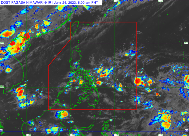
A low pressure area was spotted outside the Philippines. Meanwhile, the ITCZ is still affecting Southern Luzon, Visayas, and Mindanao. (Photo from Pagasa)
MANILA, Philippines – A low pressure area (LPA) spotted outside the Philippine area of responsibility is being monitored by the state weather bureau, it confirmed on Saturday.
In a public weather forecast, Philippine Atmospheric, Geophysical and Astronomical Services Administration (Pagasa) Weather Specialist Daniel Villamil said they are not ruling out the possibility of this LPA, at least 1,505 kilometers east of Mindanao, to develop into a tropical cyclone in the coming days.
“Hindi natin tinatanggal ‘yung posibilidad o tiyansa na itong LPA ay maging isang ganap na bagyo sa mga susunod na araw. Sa ngayon ay wala pa itong ganap na epekto sa ating bansa,” said Villamil.
(We are not ruling out the possibility or chance that this LPA will become a tropical cyclone in the coming days. Currently, it has no direct effect on any part of the country.)
Article continues after this advertisementMeanwhile, the intertropical convergence zone (ITCZ) is still affecting Southern Luzon, Visayas, and Mindanao. With this, residents of Quezon, Bicol Region, Eastern Visayas, Dinagat islands, and Surigao del Norte were warned against cloudy skies with scattered rain showers and thunderstorms on Saturday.
Article continues after this advertisement“Maging handa tayo sa biglang pagbaha at pagguho ng lupa lalong lalo na sa low-lying and flood-prone areas,” Villamil furthered.
(Let us be vigilant and alert against possible flooding and landslides, especially those who are in low-lying and flood-prone areas.)
The rest of the country, including Metro Manila, may expect hot and humid weather conditions with chances of scattered and intermittent rains in the afternoon or evening due to localized thunderstorms.
The predicted temperature ranges in key cities and areas across the country on Saturday are as follows:
- Metro Manila – 25°C to 32°C
- Baguio City – 17°C to 24°C
- Tagaytay – 22°C to 31°C
- Laoag – 26°C to 33°C
- Tuguegarao – 27°C to 36°C
- Legazpi City – 26°C to 33°C
- Puerto Princesa City – 25°C to 30°C
- Kalayaan Islands – 26°C to 31°C
- Tacloban City – 26°C to 31°C
- Iloilo City – 27°C to 32°C
- Cebu – 26°C to 31°C
- Cagayan de Oro City – 25°C to 31°C
- Zamboanga City – 25°C to 33°C
- Davao City – 24°C to 32°C
RELATED STORIES
Pagasa: 10-15 tropical cyclones possible until October as rainy season begins
Pagasa: ITCZ to still cause rain, thunderstorms over parts of PH
Pagasa: Flood, landslides possible during intense downpour due to ITCZ