How old is ‘restive’ Mayon? No one’s certain but ‘perfect symmetry’ gives clue
COMPOSITE IMAGE: JEROME CRISTOBAL FROM INQ FILE, CONTRIBUTED PHOTOS
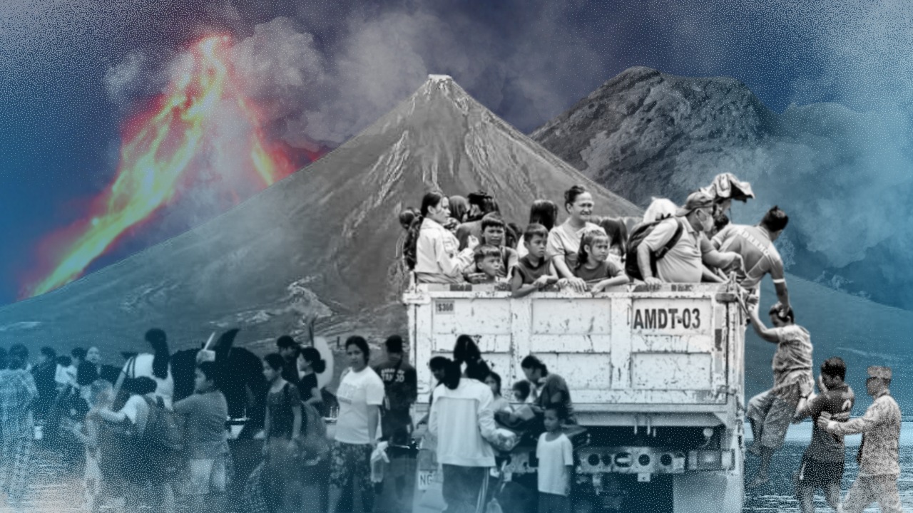
MANILA, Philippines—Mayon Volcano, which is one of the most active in the world, is restive again, leaving the government with the single option of evacuating thousands of people, especially those living inside the now 7-kilometer radius Permanent Danger Zone (PDZ).
READ: Government agencies gird for possible eruption of Mayon
But while all eyes are on the volcano’s threat of a “hazardous eruption,” which the Philippine Institute of Volcanology and Seismology (Phivolcs) said was possible “within weeks or even days,” it would be interesting to know how and when Mayon was formed.
It is already common knowledge that Mayon’s first recorded eruption was in the year 1616, but according to data from the Smithsonian Institution, there is a confirmed eruption as early as 3100 BCE ± 300 years.
So how old is the volcano, which is located in Albay province in the Bicol Region?
According to the website World Landforms, rocks within Mayon Volcano were found to be more than 20 million years old, but a study by Westen et. al. stressed that “its precise age has not been determined yet.”
But one thing is certain, they said in “Geomorphology of the Mayon Volcano and its Relation to Hazards”—Mayon Volcano is one of the youngest in the volcanic chain in the Bicol Region.
The Bicol volcanic chain, according to data from Phivolcs, includes Bulusan in Sorsogon, and Iriga and Isarog, which are both active stratovolcanoes (made of layers of lava and ash) located in Camarines Sur.

GRAPHIC Ed Lustan
The researchers stated that age estimation for Mayon Volcano was attempted by Newhall in 1977 by using three different methods that gave different results: 5,500 years old and 69,000 years old.
The 5,500 years old estimate was made when Newhall averaged the rate at which new volcanic materials are added to the cone, and then dividing this into the total volume of the cone, Westen et. al. pointed out.
The 69,000 years old estimate, meanwhile, was the product of extrapolation downward from a C14 date to an assumed base level of the cone at sea level, which was 7.9 meters, to represent 1,480 years of cone construction.
Westen et. al. also presented other research work by citing Villarta et.al., who calculated the volcano’s age to be 25,000 years old, and Punongbayan, who calculated the range of age of Mayon Volcano between 14,000 years and 52,000 years old.
But with their own study, which used the method of backward extrapolation with an average growth rate of 4.9 x 10⁶ m3, Westen et. al. estimated Mayon Volcano to be 22,000 years old.
RELATED STORY: LIVE UPDATES: Mayon Volcano
As stated in Encyclopedia Britannica, the volcano, which is a stratovolcano, has a base of 130 kilometers, or 80 miles, and rises to 8,077 feet, or 2,462 meters, above sea level.
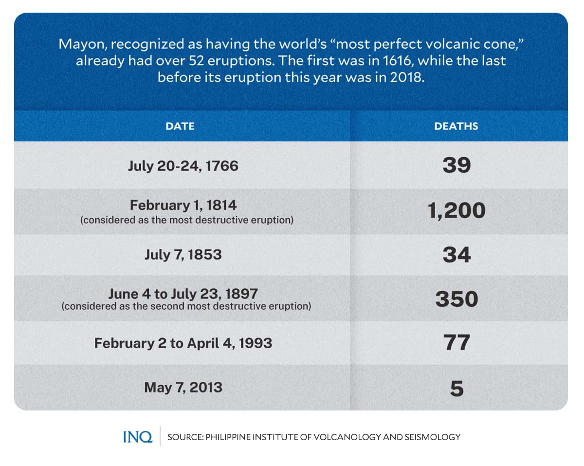
Because of this, the volcano is considered to have the “world’s most perfect volcanic cone” because of the symmetry of its shape, but the Smithsonian pointed out that this shape is somewhat because of how often it erupts.
As the website World Landforms explained, “the perfect shape [of Mayon Volcano] was formed through layers of lava flows and pyroclastic surges from erosion and past eruptions.”
According to data from Universe Today, a news website, Mayon Volcano is “located on a convergent boundary between the Eurasian and Philippine Plates,” stressing that “the lighter continental plate floats over top of the oceanic plate.”
The oceanic plate is forced down as a result, so magma wells up from the interior.
Phivolcs said the Philippines sits on a “unique tectonic setting” ideal for volcanic activities as it is located on the boundaries of two tectonic plates that dive beneath “the archipelago along the deep trenches along its east and west seaboard.”
READ: Active PH volcano belt keeps eruption watch constant
The Philippines has 24 active volcanoes, including Mayon, Taal, Pinatubo, Bulusan, Kanlaon, Iriga, and Isarog, which are often placed by state volcanologists on “heightened alert.”
Dangerous when restive
Mayon Volcano is active and dangerous when restive, having erupted over 50 times for the past 400 years, the most destructive of which was in 1814, when five municipalities in its periphery were destroyed. Here are some of the volcano’s deadly eruptions:
- July 20-24, 1766
This was Mayon Volcano’s second eruption since 1616 and was described by Phivolcs as Vulcanian, which is characterized by a dense cloud of ash-laden gas. It had a 10 to 15-kilometer eruption column.
Its pyroclastic and lava flows toward the east, and the bombs and ash fall destroyed the towns of Malinao and caused severe damage to the towns of Cagsawa, Guinobatan, Budiao, and Polang, killing 39 individuals.
- Feb. 1, 1814
A Plinian eruption, which is an “extremely explosive one,” is considered as the most destructive, with its pyroclastic flows, volcanic lighting, lahar and bomb leaving the towns of Camalig, Cagsawa, Budia, Guinobatan excessively damaged.
This eruption, which destroyed the historical Cagsawa Church, left 1,200 people dead.
- July 7, 1853
Highlighted by ash fall, pyroclastic flow, and lahar, this Vulcanian eruption affected the towns of Camalig, Guinobatan, Ligao, Oas, Polangui, Malilipot, Bavavay, and Cagsawa, killing 34 individuals.
- June 4 to July 23, 1897
This eruption, considered as the second most destructive, was a strong one and was characterized by tephra, pyroclastic flow, lava flow, and volcanic lighting, with its violent phase lasting for 17 hours.
Its pyroclastic flows destroyed Ligao, the seashore of Santo Domingo and some of its barangays—Sto. Nino, San Isidro, San Roque, San Antonio, Misericordia—and parts of Bigaa, San Fernando, and Legazpi.
The lava flow, meanwhile, affected the Basud River in Santo Domingo and the town of Camalig. At least 350 people were killed, most likely because of the volcano’s pyroclastic flows.
- Feb. 2 to April 4, 1993
Characterized by pyroclastic flow, lava flow, lahar, and a one to five-kilometer eruption column, this eruption was described as Vulcanian-Strombolian and left at least 77 people dead. Five were recorded wounded.
The towns of Mabinit and Bonga were destroyed by pyroclastic flows, while ash fall damaged Camalig, Santo Domingo, and Legazpi. Lava flow and lahar, meanwhile, were confined to gullies.
- May 7, 2013
A phreatic eruption, which caused Mayon Volcano to spew ash that reached 500 meters above its crater, killed five individuals. The eruption lasted for 73 to 146 seconds, Phivolcs said.
GRAPHIC Ed Lustan
Evacuations
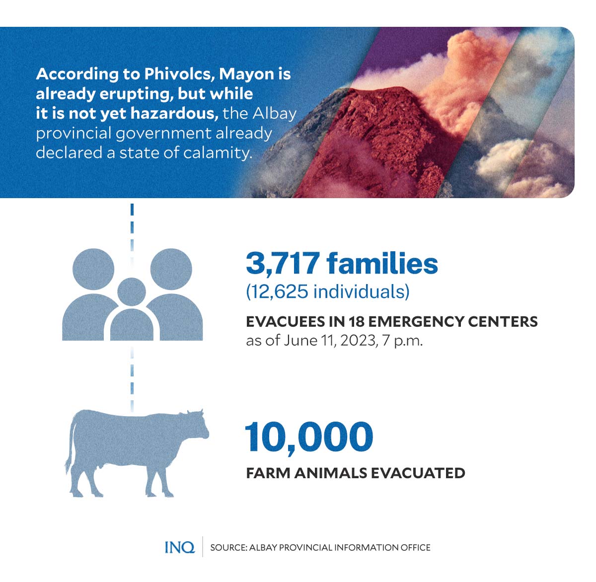
Phivolcs said that the Alert Level 3, which it raised over Mayon Volcano last Thursday (June 8), still prevails because of “relatively high level of unrest” as “magma is at the crater.”
READ: Mayon: Alert Level 3 up as rockfalls increase; ‘explosive activity’ seen in weeks- Phivolcs
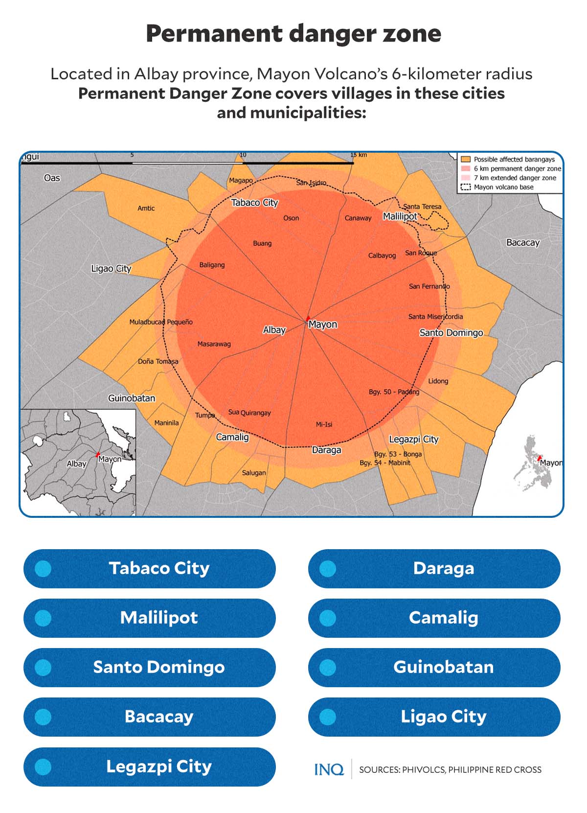
Because of this, it was recommended that the six-kilometer radius PDZ, which has now been extended to seven kilometers, be evacuated because of the danger of pyroclastic density currents, lava flows, rockfalls and other volcanic hazards.
The Albay Provincial Information Office said 88 percent of residents within the PDZ, which covers barangays in Tabaco City, Legazpi City Ligao City, Malilipot, Santo Domingo, Bacacay, Daraga, Camalig, and Guinobatan, have already been evacuated.
This, it said on Sunday (June 11), translates to 3,717 households or 12,625 individuals. Likewise, some 10,000 farm animals have been evacuated from the PDZ, which covers 41 barangays.
Based on latest data from Phivolcs, the volcano’s edifice has been “inflated” since last week and it emitted 642 metric tons (a jumbo jet would weigh 442 metric tons during takeoff) of sulfur dioxide per day on June 11. There have been three pyroclastic density current events, too.
GRAPHIC Ed Lustan
Phivolcs also recorded 260 rockfall events and 21 volcanic earthquakes, with the government institution saying that Mayon Volcano already had an effusive eruption. However, it said there is no need yet to raise the alert status to level 4.
READ: Mayon’s ominous Alert Level 3 stays; effusive eruption, 21 volcanic quakes recorded
But the provincial government already extended to seven kilometers the PDZ, stressing that evacuation will be executed anytime and the residents should bring with them necessities in evacuation centers.
GRAPHIC Ed Lustan
READ: Mayon’s danger zone extended to 7-kilometer radius