
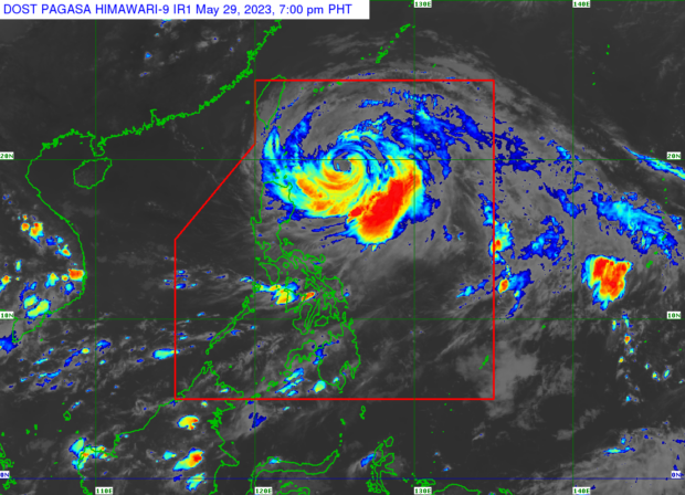
Typhoon ‘Betty’ from the satellite image of Pagasa
MANILA, Philippines — Typhoon ‘Betty’ (international name ‘Mawar’) slowed down but maintained its strength as it moved over the Philippine sea near extreme northern Luzon.
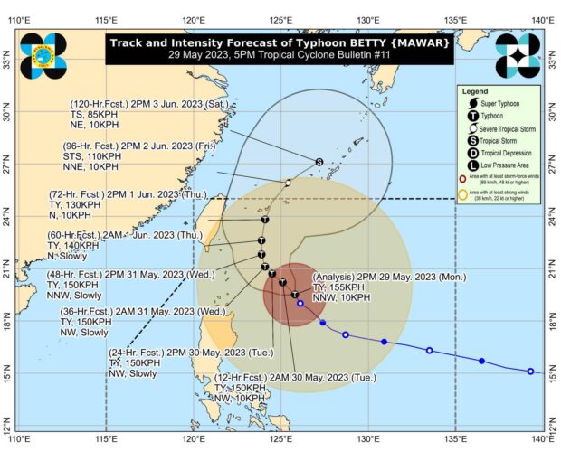
According to Pagasa weather specialist Aldczar Aurelio, Betty was last spotted 445 kilometers east of Calayan, Cagayan, carrying maximum sustained winds of 155 kilometers per hour (kph) and gusts of up to 190 kph.
“Kanina po nasa 20 km ang pagkilos ng bagyo. Ngayon ay nasa 10 kph. So bumagal ang pagkilos nito habang binabaybay ang karagatan na papalapit sa extreme Northern Luzon,” said Aurelio.
(Previously, the typhoon’s movement was at 20 km. Now it is at 10 kph. So, its movement has slowed down as it moves along the ocean approaching extreme Northern Luzon.)
“Kasalukuyan po itong radius ng bagyo ay nahahagip na po ang parte ng Eastern Northern Luzon,” he added.
(Currently, this typhoon’s radius has already hit the part of eastern Northern Luzon.)

Typhoon ‘Betty.’ (Photo courtesy of Pagasa)
“Samantala, itong habagat o southwest monsoon na naapektuhan ang Southern Luzon, Visayas at Mindanao kaya nakakaranas tayo ng malakas na hangin dito sa Metro Manila dulot po yan ng hanging habagat,” he noted.
(Meanwhile, the southwest monsoon affects Southern Luzon, Visayas, and Mindanao, which is why we are experiencing strong winds here in Metro Manila.)
Meanwhile, Tropical Cyclone Wind Signal (TCWS) No. 2 (strong winds with minor to moderate threat to life and property) is still in effect in Batanes, the northeastern portion of Cagayan and Babuyan Islands.
TCWS No. 1 (strong winds with minimal to minor threat to life and property), on the other hand, is still raised over the rest of mainland Cagayan; Isabela; Apayao, Ilocos Norte, Abra, Kalinga, Mountain Province, Ifugao, northern and central portions of Aurora, Quirino, northeastern portion of Nueva Vizcaya, northern portion of Catanduanes, northeastern portion of Camarines Sur, Polillo Islands, northern portion of Camarines Norte, as well as the northern and central portions of Ilocos Sur.
“Betty will generally move northwestward slowly today and may become slow moving or almost stationary from tomorrow [Tuesday] to Wednesday while over the waters east of Batanes,” Pagasa said.
“Afterwards, the typhoon will turn north-northeastward or northeastward on late Wednesday or Thursday and gradually accelerate towards the waters east of Taiwan,” it added.
The typhoon is expected to weaken over the next five days.
It may be downgraded into a severe tropical storm on Thursday night or Friday morning.
Betty is forecast to exit the Philippine Area of Responsibility by Friday.
Rainfall forecast
50 to 100 millimeters (mm): Batanes, the eastern portion of Babuyan Islands, Ilocos Norte, the northern portion of Ilocos Sur, the northern portion of Apayao, and the northeastern portion of mainland Cagayan (from Monday night to Tuesday afternoon)
100 to 200 mm: Ilocos Norte, Ilocos Sur, La Union, Abra, Benguet, Batanes, and the eastern portion of Babuyan Islands (from Tuesday afternoon to Wednesday afternoon)
50 to 100 mm: The rest of Babuyan Islands, Apayao, and the northern portion of mainland Cagayan (from Tuesday afternoon to Wednesday afternoon)
100 to 200 mm: Batanes, Ilocos Sur, La Union, and the western portions of Abra and Benguet
50 to 100 mm: Babuyan Islands, the rest of Ilocos Region, Abra, and the rest of Abra and Benguet (from Wednesday afternoon to Thursday afternoon)
50 to 100 mm: Batanes, Babuyan Islands, and Ilocos region (from Thursday afternoon to Friday afternoon)