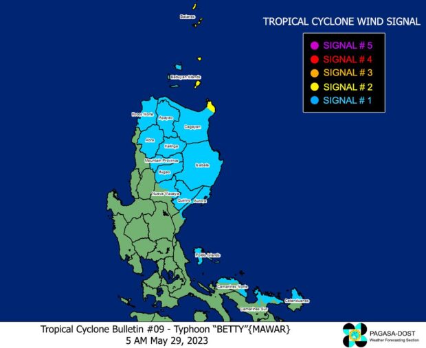
Photo from DOST-Pagasa
MANILA, Philippines — Typhoon Betty (international name: Mawar) has slightly accelerated as it moved northwestward and over the waters east of Cagayan province, the Philippine Atmospheric, Geophysical and Astronomical Services Administration (Pagasa) said Monday.
“Medyo bumilis ‘yung bagyo nasa 20 kilometers [per hour] ito pahilagang kanluran. Pero inaasahan natin sa mga susunod na araw muli itong magiging stationary lalo na kapag bandang araw ng Miyerkules at Huwebes pa northeastward palabas naman ng PAR,” Pagasa weather specialist Obet Badrina said in an early morning press briefing.
(The typhoon sped up a bit at 20 kilometers [per hour] to the northwest. But we expect that in the next few days it will become stationary again, especially around Wednesday and Thursday northeastward out of the Philippines area of responsibility.)
READ: P352 million set aside for Betty response activities
Pagasa also said in its latest weather bulletin that more areas have been placed under Tropical Cyclone Wind Signal (TCWS) No. 1 while TCWS No. 2 was hoisted in three provinces as the extent of Betty expanded on Sunday night (May 28).
Areas placed under TCWS No. 2 are Batanes, the eastern portion of Babuyan Islands, and the northern portion of Mainland Cagayan while areas where TCWS No. 1 was raised are:
- The rest of Babuyan Islands
- The rest of mainland Cagayan
- Isabela
- Quirino
- Northern portion of Nueva Vizcaya
- Apayao
- Abra
- Kalinga
- Mountain Province
- Ifugao
- Ilocos Norte
- Northern and central portions of Aurora
- Polillo Islands
- The northern portion of Catanduanes
- The northern portion of Camarines Sur
- The northern portion of Camarines Norte
Citing Pagasa’s 5 a.m., May 29, weather update, Badrina said Betty maintained its strength packing maximum sustained winds of 155 kilometers per hour (kph) near the center with gustiness of up to 190 kph.
He said the typhoon was last located 525 kilometers east of Aparri, Cagayan.
He also noted that Betty might enhance two weather systems that will likely affect the western section of the country, particularly the western parts of Mimaropa (Mindoro, Marinduque, Romblon, and Palawan) and Western Visayas, as well as western portions of Calabarzon (Cavite, Laguna, Batangas, Rizal, and Quezon), Central Luzon, and Southern Luzon.
Pagasa said flooding and rain-induced landslides are possible, especially in areas affected by the southwesterly wind flow and southwest monsoon, which is locally termed “habagat.”
READ: Typhoon Betty weakens but flash floods, landslides may still occur due to habagat
Pagasa further said it raised gale warnings as it expects turbulent sea conditions with waves as high as 3.7 to 6.0 meters in the coasts of the following areas:
- Batanes
- Cagayan
- Northeastern coast of Ilocos Norte
- Babuyan Islands
- Aurora
- Quezon including Polillo Islands
- Camarines Norte
- Camarines Sur
- Catanduanes
- Albay Sorsogon
- Batangas
- Occidental Mindoro including Lubrang Island
- Oriental Mindoro
- Marinduque
- Romblon Masbate
- Calamian Islands
- Cuyo Islands
- Aklan
- Antique
- Capiz
- Northern Samar
- Eastern Samar
- Dinagat Islands
- Surigao del Norte including Siargao and Bucas Grande Island
RELATED STORIES
Typhoon Betty’s slow down continues; Signal No. 1 over 12 provinces stays
Pagasa warns of potential flash floods, landslides across PH