
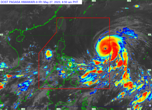
Weather satellite image from Pagasa’s website
MANILA, Philippines — The super typhoon internationally named Mawar has entered the Philippine area of responsibility early Saturday morning and will be known locally as “Betty,” the state weather bureau said.
“At 2:00 a.m. today, Super Typhoon Mawar entered the Philippine area of responsibility (PAR) and was named #BettyPH. Tropical Cyclone Bulletins will be issued beginning at 5:00 AM today,” the Philippine Atmospheric, Geophysical and Astronomical Services Administration (Pagasa) said in a social media post.
As of 3:00 a.m., the center of the eye of the super typhoon was tracked some 1,345 kilometers east of Central Luzon, packing maximum sustained winds of 195 kilometers per hour (kph) near the center with gustiness of up to 240 kph.
Pagasa said it will raise tropical cyclone wind signals for Betty on Saturday night or Sunday morning.
Betty is the second storm to hit the country this year and the first this May.
LIVE UPDATES: Super Typhoon Mawar
‘Almost stationary’
Over the weekend, the super typhoon is estimated to generally move west-northwestward, then northwestward before slowing down. Betty is predicted to become “almost stationary” between late Tuesday and early Wednesday when it will be nearest Batanes.
“Over the weekend, Super Typhoon Betty is forecast to track generally west northwestward.”
“On Monday, the tropical cyclone will turn northwestward and decelerate as it moves over the waters east of Extreme Northern Luzon.”
“Betty may eventually become almost stationary between late Tuesday and early Wednesday when it will be closest to Batanes (i.e., within 250-300 km),” Pagasa said in its 5:00 a.m. weather update.
READ: Super Typhoon Mawar slightly weakens; PAR entry by Saturday morning — Pagasa
And even if Betty may weaken by Monday, the state weather service said it will remain a super typhoon.
“Although it will likely maintain its strength for the next 36-48 hours, short-term intensification is not ruled out especially in the next 12 to 24 hours.”
“However, this tropical cyclone may begin weakening considerably on Monday or Tuesday during its slowdown period over the waters east of Batanes due to potential unfavorable conditions (e.g., effect of upwelling of cooler ocean water and dry air intrusion),” it said.
Rainfall outlook, sea condition
Pagasa’s also released its forecast of accumulated rainfall in several areas in northern Luzon amid the onslaught of Betty.
It said that from early morning of Monday (May 29) to early morning of Tuesday, Batanes, Babuyan Islands, and the northern portions of mainland Cagayan, Ilocos Norte, and Apayao may have 50-100 millimeters (mm) of rainfall.
READ: Super Typhoon Mawar even stronger as it roars closer to PAR border
As for Tuesday through early morning of Wednesday (May 31), Pagasa said Batanes may have “greater than 200 mm” of rainfall; Babuyan Islands, Ilocos Norte, Ilocos Sur, and La Union, 100-200 mm; and Cordillera Administrative Region and the northern portion of mainland Cagayan, 50-100 mm.
Meanwhile, the state weather bureau disclosed that in the next 24 hours, the eastern seaboards of Luzon and Visayas will experience moderate to rough (1.5 to 3.5 m) sea conditions – which may become rough to very rough (2.5 to 5.0 m) on Saturday afternoon or evening.
Also, the northern seaboard of Luzon may experience moderate to rough seas (1.5 to 3.0 m) this Saturday morning through afternoon and rough seas (2.5 to 4.0 m) by Saturday night, Pagasa added.
“Mariners of small sea crafts are advised to take precautionary measures when venturing out to sea and, if possible, avoid navigating in these conditions,” Pagasa said.
RELATED STORIES
Owners urged not to leave pets behind as Super Typhoon Mawar approaches
Rain to persist in parts of PH as Super Typhoon Mawar looms outside PAR
Mawar strengthens into super typhoon again, says Pagasa
gsg/kga