Rain to persist in parts of PH as Super Typhoon Mawar looms outside PAR
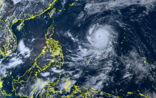
Track of Super Typhoon Mawar as of May 26, 2023 at 1:40PM | PHOTO: Screengrab from Himawari 8 weather satellite
MANILA, Philippines — Cloudy skies and rain are expected to persist until Saturday across parts of the country as Super Typhoon Mawar continues to loom outside of the Philippine area of responsibility (PAR), said the state weather bureau.
According to the Philippine Atmospheric, Geophysical and Astronomical Services Administration (Pagasa), Mawar—which will be named ‘Betty’ once it enters PAR— is currently 1,725 kilometers east of Central Luzon.
At present, Mawar has maximum sustained winds of 215 kilometers per hour and gustiness of up to 265 kilometers per hour.
Pagasa said Mawar is currently moving west-northwestward at 25 kilometers per hour.
Meanwhile, Western Visayas, Zamboanga Peninsula, Soccksargen, and BARMM will experience cloudy skies and scattered rains and thunderstorms due to the south westerly wind flow, said Pagasa.
State meteorologists also said Metro Manila and the rest of the country, meanwhile, would have partly cloudy skies with isolated rain showers due to localized thunderstorms.
For areas affected by moderate to heavy rains, Pagasa warned of possible flash floods or landslides.
RELATED STORIES:
LIST: Class suspensions on Friday, May 26, due to Mawar
Super Typhoon Mawar even stronger as it roars closer to PAR border