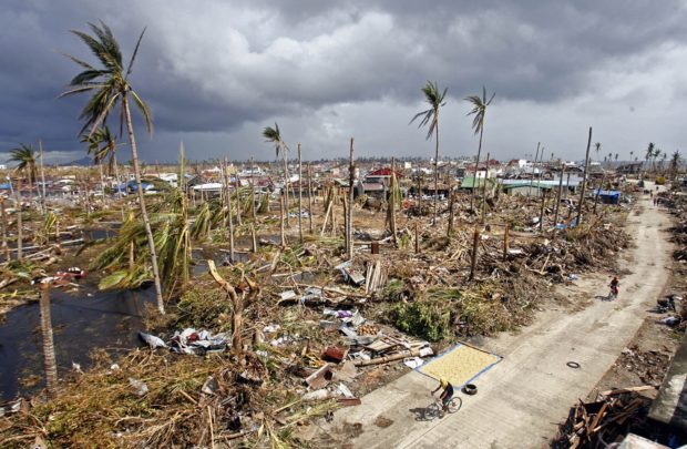
DESOLATE LANDSCAPE A seaside barangay in Palo, Leyte, is left in ruins by Supertyphoon “Yolanda” in 2013. —INQUIRER FILE PHOTO
MANILA, Philippines — State meteorologists have urged Filipinos not to be complacent just because Super Typhoon Mawar is expected to weaken once it enters the Philippine area of responsibility (PAR), as it would still be a typhoon-category cyclone.
Philippine Atmospheric, Geophysical and Astronomical Services Administration (Pagasa) officer-in-charge Dr. Esperanza Cayanan said in a press conference on Friday that Mawar, which will be named “Betty” once it crosses the PAR, would not hit the country like Super Typhoon Yolanda did in November 2013.
Yolanda is a super typhoon that packed maximum sustained winds over 220 kilometers per hour (kph).
While Mawar is expected to reach that intensity, it would not happen while the cyclone nears the Luzon land mass.
“I think 220 plus, so malakas ‘yong hangin na ‘yon (ni Yolanda). Sa ngayon 215 (kph) ‘yong lakas ng hangin ni Mawar, pero nasa dagat siya. So ‘yon ‘yong kagandahan ngayon, nasa dagat, at ‘don sa forecast track natin, hihina siya bago lumapit dito sa may bandang Batanes islands. So I think magiging typhoon intensity around 175 (kph), pero malakas pa rin ‘yon kasi typhoon,” she said.
(I think Yolanda’s winds were around 220 plus, so that’s strong. As of now Mawar has maximum sustained winds of 215 (kph), but it is still over waters. That’s a better situation, because according to our forecast track, it would weaken before nearing the Batanes islands. So I think it would be a typhoon intensity around 175 (kph), but that is still strong.)
“So mas mahina siya kay Yolanda (habang) lalapit dito sa isla, but siguro ‘wag nating isipin na mahina ‘yong bagyo, kasi typhoon intensity, meron pa rin ‘yang bugso — ‘yong gustiness kasi ay iba pa, mas mataas kasi ‘yon doon sa maximum sustained winds,” she added.
(So it would be weaker than Yolanda as it nears the islands, but maybe let’s not think of it as a weak one because it is a typhoon, it still has gusts — gustiness is different, it is stronger than maximum sustained winds.)
Pagasa’s latest weather bulletin on Mawar showed that the cyclone is still packing maximum sustained winds of 215 kilometers per hour (kph) near the center, and gustiness of up to 260 kph.
It was last seen 1,705 kilometers east of southeastern Luzon, moving west at the speed of 20 kph.
“So pwedeng may biglang bugso ng hangin na malalakas na pwedeng magpatumba ng puno, magpalipad ng mga bubong doon sa direktang tatamaan nito,” Cayanan said.
(So the sudden bursts of strong winds can bring trees down, lift roofings in areas directly affected.)
Weather specialist Ana Clauren-Jorda also mentioned the same thing, saying that while Betty is expected to weaken as it moves inside the PAR, people should not be complacent as it may still carry wind speeds of at least 170 kph.
“Posible pa ring lumakas itong si bagyong si Mawar or magiging si Betty at umabot sa 220 kph ‘yong kanyang maximum sustained winds. Ngunit ‘pag pasok po nito ng ating PAR posible rin po itong unti-unting mag-weaken, pero mapapanatili pa rin nito ‘yong kanyang super typhoon category hanggang Monday nang umaga,” Clauren-Jorda said.
(Mawar can still intensify its maximum sustained winds up to 220 kph but once it enters par, it would gradually weaken and would remain a super typhoon category cyclone up to Monday morning.)
“At ‘pag dating po ng Monday ng gabi or Tuesday ng umaga, posible po itong humina into a typhoon category. Pero hindi po dapat tayo magpakampante na ‘ah, humihina po itong bagyo’, ‘yong typhoon category po ay malakas pa rin, posible pa ring umabot sa 175 kph ‘yong kanyang maximum sustained winds,” she added.
(And by Monday or Tuesday morning, it can weaken further into a typhoon category cyclone. But we should not be complacent and think that the cyclone is weak — a typhoon category cyclone is still strong, and can reach maximum sustained winds of 175 kph.)
Pagasa said Mawar may enter PAR between Friday night and Saturday morning as a super typhoon, moving on a west northwest pattern. It may be nearest to the Luzon landmass between Monday morning and Tuesday morning.
Mawar’s cone of probability also shows that a landfall scenario is less likely, but should the cyclone move south, it would hit northern towns of Cagayan.
Landfall or not, Pagasa said tropical cyclone wind signals may still be raised, and that heavy rainfall can be expected over Northern Luzon starting Sunday night or Monday morning.
RELATED STORY:
Super Typhoon Mawar even stronger as it gets nearer to PAR border