Super Typhoon Mawar may enter PAR on Friday night
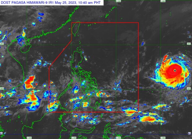
Weather satellite image of Super Typhoon Mawar from Pagasa’s website
MANILA, Philippines — Super Typhoon Mawar may enter the Philippine area of responsibility (PAR) on Friday night, the state weather bureau said late Thursday afternoon.
In a press briefing, the Philippine Atmospheric, Geophysical and Astronomical Services Administration (Pagasa) said Mawar was last monitored some 2,000 kilometers east of Southeastern Luzon – still outside PAR.
It is moving west northwestward at 15 kilometers per hour, with maximum sustained winds of 195 km/h and gustiness of up to 240 km/h.
“This may enter the Philippine area of responsibility starting tomorrow evening or Saturday morning,” state weather specialist Daniel James Villamil said in Filipino.
Article continues after this advertisementMawar may reach a peak intensity of 215 km/h by Sunday, he added.
Article continues after this advertisementPagasa is not ruling out the possibility of Mawar’s movement slightly shifting southward in the next few days.
“It may have a much closer approach to the country. This will affect extreme Northern Luzon areas the most, including Batanes, Babuyan Islands, as well as mainland Cagayan,” Villamil said.
Based on Pagasa’s forecast, he said Mawar may trigger heavy rain in Cagayan Valley between Sunday and Tuesday next week.
Villamil also pointed to another “concern” that Pagasa is monitoring: Mawar may enhance the southwest monsoon over the weekend until early next week.
READ: Super Typhoon Mawar may whip up monsoon rain in Luzon, Visayas next week
This, in effect, will dump rain in the western portion of the country, including Metro Manila.
Southwesterly wind flow
Villamil reiterated that Mawar, which has yet to enter PAR, is not directly affecting the country at this time.
But, he said, the southwesterly wind flow is.
“In the western section of Southern Luzon, Visayas, and Mindanao, they will encounter overcast skies and scattered rain, thunderstorms, and lightning,” Villamil said.
This weather will persist in Palawan, Western Visayas, Northern Mindanao, Zamboanga Peninsula, Soccsksargen, and Bangsamoro, he added.
RELATED STORIES:
Mawar strengthens into super typhoon again, says Pagasa
Mawar weakens, but evacuations readied in Cagayan, Bicol regions