Typhoon Mawar to regain supertyphoon status on Thursday at earliest
MANILA, Philippines — Mawar, a typhoon approaching the Philippine area of responsibility, could re-intensify into a supertyphoon by Thursday at the earliest, the state meteorologists said.
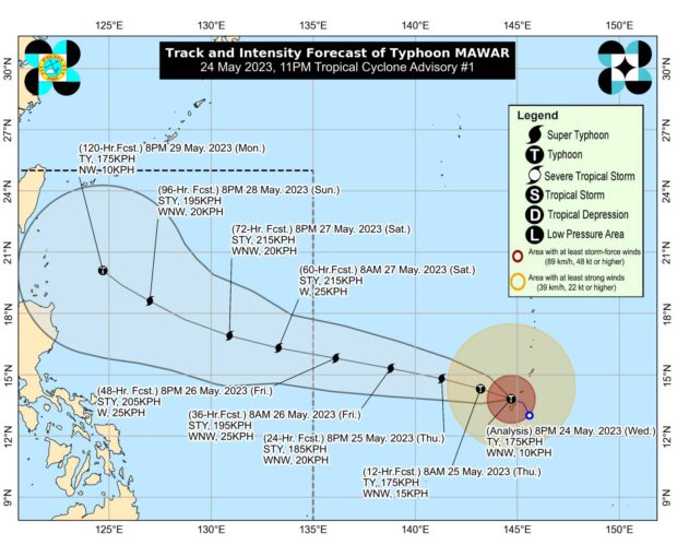
“Mawar is forecast to re-intensify within the next 3 days and may regain its super typhoon status by tomorrow at the earliest,” the Philippine Atmospheric, Geophysical and Astronomical Services Administration (Pagasa) said in its 11 p.m. update on Wednesday.
As of 10:00 pm, Pagasa said the center of the eye of Mawar was estimated to be 2,205 kilometers east of southeastern Luzon, packing maximum sustained winds of 175 kilometers per hour (kph) with gustiness of 215 kph. It is moving west-northwest at 10 kph.
This tropical cyclone is also forecast to reach its peak intensity of 215 kph on Saturday, according to Pagasa.
The strong to gale-force conditions may be experienced, which could lead to the hoisting of tropical cyclone wind signal “in the coming days.”
Article continues after this advertisementThe typhoon’s track also shows that the rain bands over the typhoon could affect Cagayan Valley between Sunday and Tuesday next week, according to the state weather bureau.
In anticipation of the typhoon, the Office of Civil Defense is preparing for preventive evacuation in the provinces of Cagayan Valley and Batanes.