Approaching LPA now a tropical depression, may enter PAR next week
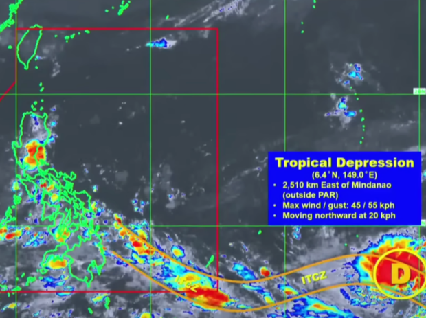
Himawari Enhanced Infrared Image of the tropical depression being monitored by Pagasa on Saturday, May 20, 2023. Photo from DOST-PAGASA
MANILA, Philippines — The Philippine weather authority reported Saturday that the low pressure area (LPA) earlier spotted east of Mindanao is now a tropical depression or weak storm.
In an advisory, the Philippine Atmospheric, Geophysical and Astronomical Services Administration (Pagasa) said the LPA is still outside the Philippine area of responsibility (PAR), specifically, 2,500 kilometers east of Mindanao as of 3 a.m.
This LPA is still anticipated to enter the PAR by the end of next week.
“Isang ganap na po na bagyo or tropical depression ang LPA sa labas ng PAR,” said Pagasa weather specialist Benison Estareja.
(The LPA is now a storm or tropical depression outside the PAR.)
Article continues after this advertisementREAD: Pagasa spots new LPA that may turn into weak storm in 2-4 days
Article continues after this advertisement“Samantala, itong tropical depression sa ngayon na posibleng maging lalakas pa na bagyo ay papasok ng PAR – kung magpapatuloy ang northwest movement nito – by Friday or Saturday of next week pa,” he added.
(Meanwhile, this tropical depression at the moment, which is likely to become a stronger storm, will enter PAR – if its northwest movement continues – by Friday or Saturday of next week.)
By then, Pagasa said it will name the weather disturbance “Betty.” It would be the second storm to enter the PAR this year and the first for this month. The name Betty was also used for a typhoon that hit the Philippines in 2015 and 2019. But Pagasa may reuse one of four sets of typhoon names on a four-year rotation.
Estareja then explained that the LPA currently appears to move northward although it may begin to veer northwestward by Sunday, May 21.
READ: Isolated rains possible over Mindanao due to ITCZ – Pagasa
“From Sunday to Wednesday, posibleng nasa may Guam po ito. From Wednesday, inaasahang kikilos na ito northwestward. At hindi rin natin inaalis ‘yung possibility na mas lalakas pa ito either by typhoon or super typhoon,” said Estareja.
(From Sunday to Wednesday, it may be near Guam. From Wednesday, it is expected to move northwestward. And we are not eliminating the possibility that it will get stronger either by typhoon or super typhoon.)
Nevertheless, the state weather specialist noted that considering the LPA’s present trajectory, it may not hit the country’s landmass. But it is expected to “enhance” southwest monsoons in many parts of the country over the next week.
Estareja added that the weak storm is currently enveloped in the inter-tropical convergence zone or ITCZ that’s been bringing rain to various areas of the country.
READ: Pagasa says rain possible over parts of PH due to ITCZ