BuCor HQ at Masungi Georeserve: What’s really at stake?
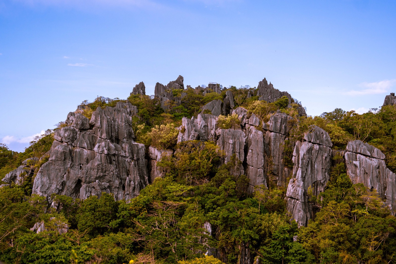
PHOTO FROM MASUNGI GEORESERVE
MANILA, Philippines—“Twenty years in the making,” the Masungi Georeserve has “successfully made progress in watershed rehabilitation and protection” within the threatened landscape of Rizal province.
Since the 2000s, the Masungi Georeserve Foundation (MGF) has conserved and rehabilitated the landscape, which is a 300-hectare land in the Sierra Madre Mountain Range.
“Trees are now growing taller, the wildlife is slowly but certainly getting richer,” the MGF said of the georeserve, which in 1996 was dedicated to conservation and restoration.
GRAPHIC Jerome Cristobal
But not even a year has passed since the attack of seven park rangers by a mob of 20 to 30 people and the “attempted invasion” of over 30 armed men, the landscape is feared to be put at risk once again.
READ: Masungi: Watershed protecting NCR under attack with impunity

GRAPHIC Kurt Dela Peña
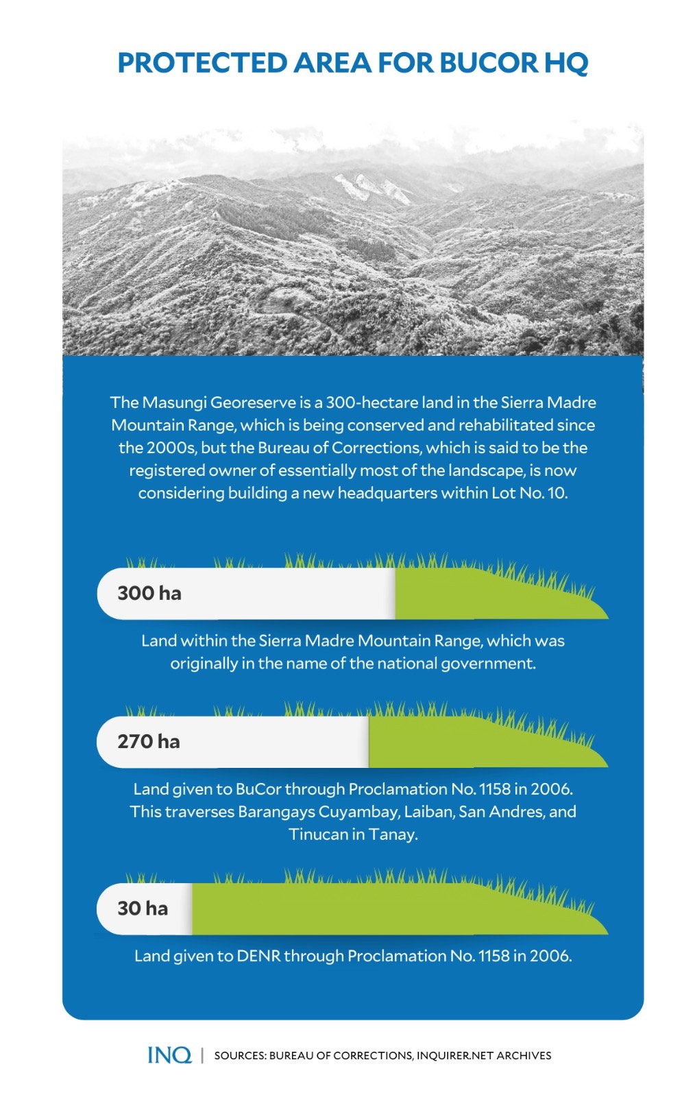
This, as the Bureau of Corrections (BuCor) said it has a plan to build a new headquarters within the Masungi Georeserve, stressing that the bureau is the registered owner of 270 hectares, essentially most of the landscape.
READ: BuCor eyes new HQ, staff housing in protected area
BuCor officer-in-charge Gregorio Catapang Jr. said a transfer certificate of title for the land in Barangays Cuyambay, Laiban, San Andres and Tinucan in Tanay town was awarded to the BuCor last year.
Looking back, the 270 hectares and a separate 30 hectares for the Department of Environment and Natural Resources (DENR) were under the name of the national government in Certificate of Title No. 3556.
However, when Proclamation No. 1158 was signed in 2006 by then President Gloria Macapagal-Arroyo, the BuCor and the DENR were given rights to the land.
This was the reason that BuCor is now planning to build a new headquarters, a residential area for its staff, and an agro-production area within the landscape’s Lot 10.
But there’s a problem.
As stressed by the MGF on Feb. 16, when 20 men from the BuCor arrived at the georeserve to conduct an “ocular inspection,” Lot 10 was found to be part of several protected and conserved areas:
National Park, Wildlife Sanctuary and Game Preserve (Proclamation No. 1636, which was signed in 1977 by then President Ferdinand Marcos Sr.)
Proposed Masungi Strict Nature Reserve and Wildlife Sanctuary (DENR Administrative Order No. 33, which was issued in 1993 by then environment secretary Angel Alcala)
Kaliwa River Forest Reserve (Proclamation No. 573, which was signed in 1969 by Marcos Sr.)
GRAPHIC Jerome Cristobal
The MGF said Lot 10 is part of hundreds of hectares of land, which were equitized in a conservation and rehabilitation project in 2002 by the DENR and Blue Star Construction and Development Corp.
It also includes the latest MGF initiative with the government—the Masungi Geopark Project (MGP)—which it said is “at the forefront of the Philippines’ climate change agenda.”
Looking back, it was in 2017 when the DENR asked MGF to help preserve 2,700 hectares of protected landscape, especially the Upper Marikina River Basin protected Landscape (UMRBPL).
Serious implications
While Justice Secretary Jesus Crispin Remulla said the BuCor’s plan is not yet final, with Catapang stressing that they will first seek the approval of experts, the BuCor’s move is already raising concerns.
READ: BuCor project in Masungi to push through if experts approve — Catapang Jr.
Last Feb. 21, Sen. Nancy Binay filed Senate Resolution No. 495 to seek intervention, stressing that the Senate should look into the plan of the BuCor.
“The Masungi Georeserve is a symbol of sustainable development and at the forefront of efforts to conserve, restore and improve the environment in the face of climate change, which must be protected […] at all cost.”
Binay, chair of the Senate Committee on Tourism, said while BuCor’s reason for developing the area was “reasonable, it is important to weigh the possible consequences.”
She said the plan “may affect the environment and tourism in the country,” stressing the implications of building a structure in an ecotourism area like the Masungi Georeserve.
GRAPHIC Jerome Cristobal
Even Rep. Raoul Manuel (Kabataan), who visited Lot 10 on Friday (Feb. 24) with the group Kalikasan PNE, said he will file a resolution that will “express the sense of the House of Representatives.”
‘Ark of biodiversity’
As stressed by the MGF, the Masungi Georeserve is possibly the only remaining large exposure of rock from the Paleocene age in the Philippines.
Based on a report by the National Museum of the Philippines (NMP) last year, the Philippines is gifted with abundant landforms scattered all over the country.
One of these is karst, it said, a limestone formation created by water sinking and circulating below the ground, resulting in the chemical erosion of bedrock.
GRAPHIC Jerome Cristobal
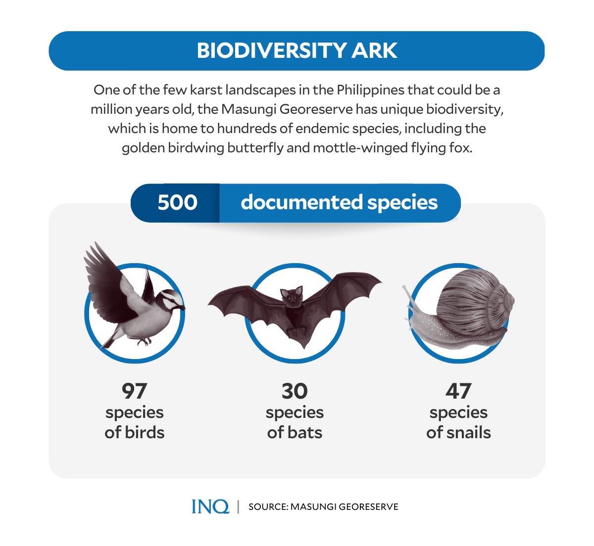
The MGF said one of the few karst landscapes in the Philippines that could be estimated to be millions of years old, the Masungi Georeserve has a unique biodiversity, which is home to endemic species.
Ann Dumaliang, managing trustee of the Masungi Georeserve, told INQUIRER.net that “we have been able to document more than 500 species of flora and fauna.”
These include 97 species of birds, 47 species of snails, which is the highest in the Philippines, and 30 species of bats, like the Mottle-Winged Flying Fox.
As Dumaliang said, these species include rare ones, like the JC’s Vine, which has been documented only in five places in the Philippines, the Masungi Microsnail, and Scale-Feathered Malkoha.
The NMP said the formation of the landscape takes hundreds of years. “It is home to significant geological, biological, and even cultural resources.”
No construction, please?
But Dumaliang said “as a karst ecosystem comprising a network of caves, sinkholes, and even underground systems, it can be massively impacted by whatever occurs in its surroundings.”
Catapang earlier said the BuCor will use only 20 to 30 hectares out of the 270 hectares, and that it will only be on “vacant spaces” at the bottom of the landscape.
As the NMP and the World Commission on Protected Areas explained, any karst environment depends on the relationship of water, land, vegetation, and soil.
It said while activities such as developmental ones in the vicinity of the Masungi Geopark may not cause direct destruction on the geopark itself, the activities may disrupt karst systems.
This was the reason that construction of any permanent structures is prohibited.
The NMP said developments such as, but not limited to, establishment of facilities, construction of concrete roads or hiking trails, or the permission of any vigorous anthropological activities may become a triggering event for sinkhole collapse.
This, as the Masungi Georeserve is made of soluble rocks known as limestone. Such lithology is very critically susceptible to the formation of cavities, which eventually become large cave systems.
“These cavities are not usually known unless their roof collapses to form sinkholes.”
As stressed by the MGF, the area is “mountainous and geologically unbuildable,” saying that the development will be financially prohibitive, and in the words of scientists from the NMP, will have “expensive consequences” for the environment.
Masungi’s carbon sink
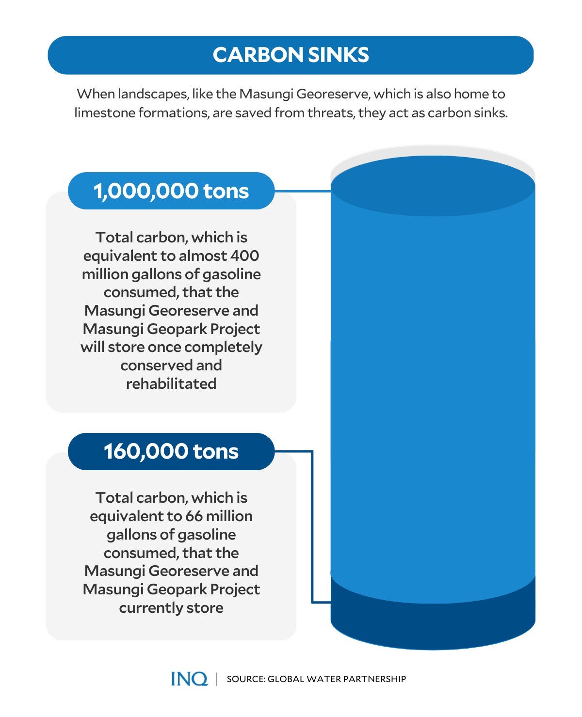
The Global Water Partnership said conserving the Masungi Georeserve and MGP will help strengthen resilience to climate changes, especially by protecting and rehabilitating the forests in the watershed and its biodiversity.
It said when landscapes are saved from threats, they act as carbon sinks, stressing that so far, the Masungi Georeserve and MGP presently store an estimated 160,000 tons of carbon, equivalent to 66 million gallons of gasoline consumed.
“Once fully restored, the area will be able to store almost one million tons of carbon and sequester even more every year,” the Global Water Partnership said.
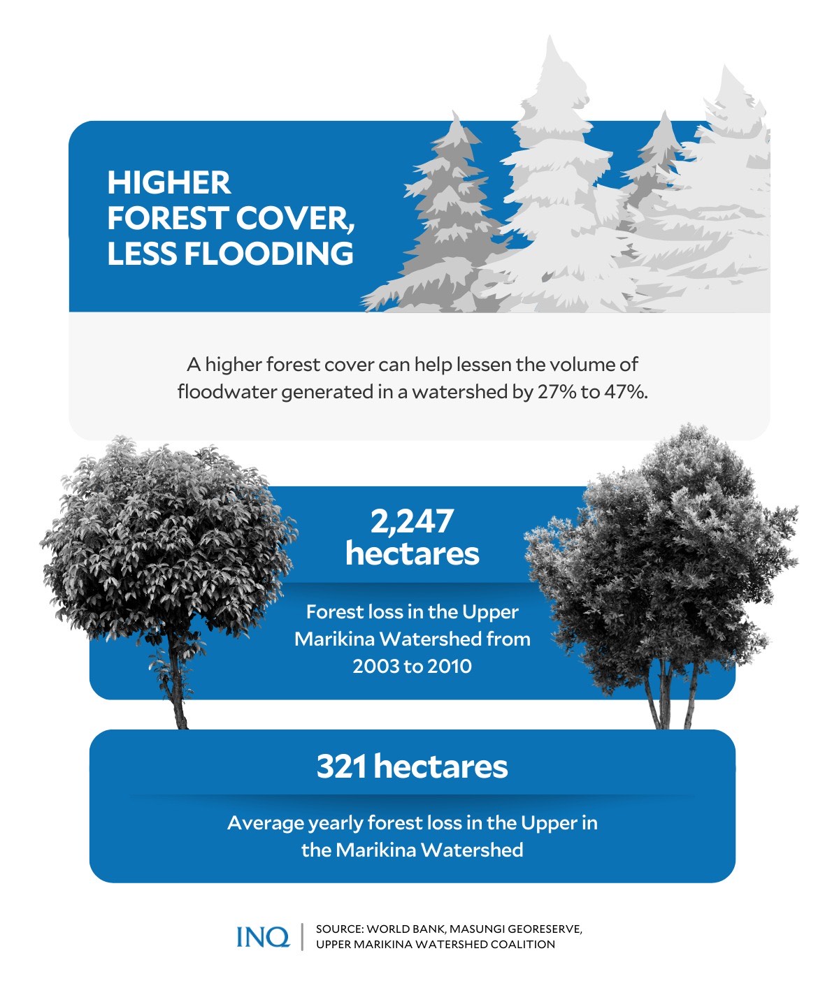
The problem, however, is that from 2003 to 2010, the UMRBPL lost a significant area of 2,247 hectares, or an average of 321 hectares yearly, the Upper Marikina Watershed Coalition said.
“In 2015, there was only 21.1 percent estimated forest cover left in the Upper Marikina Watershed. Parts of the watershed are still under threat as mining, quarrying, professional squatting, and large-scale illegal logging continues,” it said.
A conserved UMRBPL translates to the preservation of the Masungi Georeserve––the home of 60-year-old limestone formations and over 500 species of flora and fauna.
Catch basin
Looking back, when Tropical Storm Ondoy hit in 2009, the failure of the watershed to hold water led to one of the deadliest disasters to hit the National Capital Region (NCR).
Then when Typhoon Ulysses hit in 2020, the Advocates of Science and Technology for the People said the degraded condition of watersheds upstream the Marikina-Pasig was also a critical factor in the floods that hit communities.
RELATED STORY: Makabayan solon slams BuCor plan to build HQ in Masungi Georeserve
“If a watershed is no longer healthy, when there are no trees and no vegetation, runoff water can easily travel down from the mountains and toward the rivers and other channels,” it said.
As stressed by the MGF, a higher forest cover can lower possible flood water volume by 27 percent to 47 percent versus a ‘No Forest’ cover simulation by the World Bank in the Upper Marikina Watershed.
GRAPHIC Kurt Dela Peña
Dumaliang told INQUIRER.net that Lot 10 contains the main rock spine of the karst formation: “This area is also tactically important in preventing encroachment further up the watershed.”
“It is especially sensitive in the system being the watershed divide (highest points of the watershed).”
Dumaliang previously said UMRBPL is very critical not only for the communities within and on its edges because it’s also significant for NCR.
“It’s really something that affects some 20 million Filipinos who rely on this watershed,” she said, stressing that illegal activities have deep impact on the quality and amount of water, siltation of waterways, and even soil quality.
A watershed is an area of land that drains or “sheds” water into another body of water. In this case, water from the Sierra Madre flows through these areas all the way down the Pasig River, Marikina River and Laguna de Bay:
- Antipolo
- Baras
- General Nakar
- Rodriguez
- San Mateo
- Tanay
The MGF stressed in 2020 that “there should be no other recourse but to conserve what’s left of the watershed, restore the forest, and remove all incompatible activities within it.”
Gov’t is pro-environment
“There are many viable alternative sites elsewhere. Masungi is a priceless legacy of the nation that should be preserved at all costs instead of destroyed,” the MGF said.
But Remulla clarified that the development plans for the bureau’s 270-hectare property within the protected area in Tanay, would be “pro-environment.”
READ: DOJ, BuCor: Development plans for Masungi will be pro-environment
He said: “Secretary Loyzaga and I talked yesterday and will speak with one voice on this matter. There should be no problem. We’re pro-environment, the environment is not our enemy.” He was referring to current Environment Secretary Maria Antonia Yulo Loyzaga.
“We are exploring everything. Actually, there’s no final decision on that yet… but definitely, we will be needing some of the land that’s not part of the reserve. But most likely we’re thinking of [a prison] for young offenders or women offenders for the [NCR],” Remulla said.
However, he said they would utilize only the “unused” portion of the geopark: “What’s important to Masungi is to preserve it. But the other land areas that are not being used will be used by the government.”
“Even the title of Masungi belongs to the government. It’s the heritage of the Filipino people, it does not belong to one foundation but to all the Filipino people.”
BuCor’s plan to move out of Muntinlupa City was part of the “BuCor Development and Modernization Plan 2023-2028.”
READ: Remulla defends BuCor relocation to Masungi as part of decongestion plan
TSB