Mayon’s rough terrain hard for rescuers looking for crashed plane

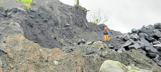
PERILOUS PATH | A member of the search and rescue team tasked to find the wreckage of the Cessna plane that crashed on Mt. Mayon on Feb. 18, 2023, navigates through a section of the volcano’s slope on Wednesday, careful not to slip down the sandy area full of jagged volcanic rocks made slippery by days of rain. (Photo from the Facebook page of the Bureau of Fire Protection)
LEGAZPI CITY, Albay, Philippines — Members of a rescue team tasked to find the wreckage of a Cessna plane that crashed on the slope of Mayon Volcano on Feb. 18 made their final push toward the summit on Wednesday and were expected to reach the crash site by the afternoon in an attempt to rescue the four passengers.
The team members, for the second day, had to brave “critical terrain” along the volcano’s steep slopes. The ascent was made difficult by the absence of a trail from their jump-off point on Wednesday morning to the crash site, said to be about 350 meters from the summit crater of Mayon.
At a press briefing on Wednesday, Cedric Daep, chief of the Albay Public Safety and Emergency Management Office, said the 28-member team, composed of local mountaineers, the special rescue force of Bureau of Fire Protection (BFP) in Bicol, emergency response teams, and local guides, started to climb at 5 a.m. to reach the crash site.
They had to climb on Tuesday morning from two different points at the base of the volcano — Barangay Anoling in Camalig town and Barangay Mi-isi in Daraga town—and met at the 914-meter (3,000-feet) point up the trail to set up a camp where they spent the night.
Another government team was dispatched to prepare a base camp and landing site of choppers from the Philippine Air Force’s Tactical Operations Group 5 about 609 meters (2,000 feet) from the crash site. This will serve as the pick-up point of rescuers and the crash victims.
Article continues after this advertisementThe plane was carrying pilot, Capt. Rufino James Crisostomo Jr.; his mechanic, Joel Martin; and their two Australian passengers, Simon Chipperfield and Karthi Santhanam.
Article continues after this advertisementBased on the initial plan, around six to eight persons were assigned to carry each of the four victims from the crash site down to to the base camp. Some of the backup teams from the base camp would meet them halfway to help and guide them the rest of the way.
“If their [operations] are positive, the victims will be brought to the pick-up point so that we will be able to make recovery or rescue, or whatever it is, of the victims faster,” Daep told reporters at a briefing at the Camalig town hall.
He said that as of 9 a.m. Wednesday, the rescuers were at the Mi-isi channel, and needed to cross a 900-meter vegetated area to reach the Anoling channel, where the wreckage was initially located.
Daep said their operation in the gully, where the wreckage was found on Sunday by a team doing an aerial search, would be tedious as loose volcanic materials, sand, boulders and rocks might compromise their safety.
Needing guidance
To hasten the movement of the rescue team, Daep said the incident command teams were helping them plot their location and guide them.
“They need help in identifying the direction because if you are in the area, you will be disoriented … If we don’t guide them, the operations will be delayed and they might [stray],” Daep said.
He said they were in contact with rescuers but they needed to keep communication to a minimum as they needed to preserve the battery life of their gadgets.
The Philippine Institute of Volcanology and Seismology (Phivolcs) reminded the search and rescue team to prepare for contingencies for “possible hazard, such as sudden phreatic or steam-driven eruptions, especially with the recent persistent rainfall over Mayon, and rockfalls from the summit.”
“These hazards are higher on the more susceptible gullies on the slopes; the Cessna lies on a gully. The upper slopes of Mayon are also either very slippery due to bare smooth lava or unstable due to fragmented lava and near-event deposits that may be dislodged when stepped on,” Phivolcs said in a statement on Tuesday.
Daep said they were not disregarding the possibility that there are survivors four days after the crash.
Camalig Mayor Carlos Irwin Baldo Jr., the incident commander, said they were operating double time to rescue the passengers.
“We only deployed trained and qualified rescuers to fast-track the operations but we cannot give a timeline,” Baldo said.