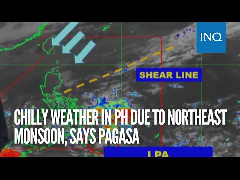
MANILA, Philippines — Bring out your jackets, as the state weather service is seeing chilly weather conditions through Christmas Day due to the northeast monsoon bringing cold winds and cloudy skies to the country.
According to the Philippine Atmospheric, Geophysical and Astronomical Services Administration (Pagasa), the northeast monsoon, which is known locally as amihan, will bring cold temperatures and overcast skies with rain across the country.
Metro Manila, Cagayan Valley, Cordillera Administrative Region, Calabarzon, and Aurora are expected to have cloudy skies and rain on Wednesday due to the effects of the northeast monsoon. The rest of Luzon will also be affected by the system but with “no significant impact,” Pagasa added.
“Northeast monsoon or amihan pa din ang umiiral dito naman sa nalalabing bahagi ng Luzon kung saan dala pa rin nito ang malamig na panahon at ‘yung maulap na kalangitan na may pag-ulan, lalong-lalo na ‘yan dito sa may bahagi ng northern Luzon, maging sa eastern section din ng southern Luzon at dito na rin sa Metro Manila at sa mga karatig lalawigan nito,” said Pagasa weather specialist Grace Castañeda.
(It’s still the northeast monsoon affecting the rest of Luzon where cold temperatures and overcast skies with rain may be experienced, especially over northern Luzon, even the eastern section of southern Luzon and here in Metro Manila.)
A weather bulletin of Pagasa showed that chilly temperatures are likely across the country until Christmas Day, dipping to as low as 13 degrees Celsius in Baguio City.

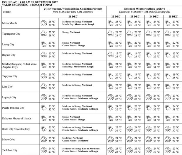
Temperature forecast from Pagasa
READ: Cool Christmas Day for Baguio, Metro Manila, and other parts of PH
In the meantime, below are the state weather bureau’s forecast temperature in key areas around the country for Wednesday, December 21:
- Metro Manila: 25 to 30 degrees Celsius
- Baguio City: 15 to 24 degrees Celsius
- Laoag City: 23 to 32 degrees Celsius
- Tuguegarao: 22 to 28 degrees Celsius
- Legazpi City: 24 to 26 degrees Celsius
- Puerto Princesa City: 25 to 32 degrees Celsius
- Tagaytay: 21 to 29 degrees Celsius
- Kalayaan Islands: 25 to 32 degrees Celsius
- Iloilo City: 25 to 30 degrees Celsius
- Cebu: 25 to 30 degrees Celsius
- Tacloban City: 24 to 27 degrees Celsius
- Cagayan De Oro City: 25 to 30 degrees Celsius
- Zamboanga City: 24 to 32 degrees Celsius
- Davao City: 24 to 32 degrees Celsius

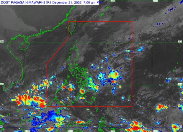
Weather satellite image from Pagasa’s website
Pagasa likewise said that a low pressure area (LPA) is also affecting the Bicol Region, Eastern Visayas, Central Visayas, Caraga and the Davao Region.
“Yung low pressure area na mino-monitor natin ay huling namataan sa layong 210 kilometers east-northeast ng Davao City. Nananatiling mababa ang tsansa nitong maging bagyo within 48 hours. Ngunit nakikita natin na patuloy itong magdudulot ng mga pag-ulan ngayong araw at sa mga sumusunod na araw pa dito sa may bahagi ng Visayas at Mindanao,” said Castañeda.
(The low pressure area we are monitoring was last spotted 210 kilometers east northeast of Davao City. It remains to have a low chance of becoming a cyclone within 48 hours. However, we see that it will continue to bring rain today and the next few days over Visayas and Mindanao).
Areas affected by rain are warned of possible landslides and flash floods.
The Bicol Region is likewise affected by the shear line prevailing over the eastern section of southern Luzon, thus, overcast skies and scattered rain showers with lightning and thunder may be anticipated in the region.
Additionally, Pagasa kept its gale warnings over parts of Luzon still due to the northeast monsoon – or the cool, dry wind coming from Siberia and China that blows down to Southeast Asia. These areas included Batanes, Cagayan including Babuyan Islands, Isabela, Aurora, northern and western coasts of Ilocos Norte, Ilocos Sur, La Union, Pangasinan, northern coast of Quezon and the northern and eastern coasts Polillo Islands.
Pagasa advised fisherfolks and those with small vessels against going out to the sea at this time.
RELATED STORIES
Three weather systems causing cooler temperatures in PH — Pagasa
LPA outside of PAR has small chance of developing into cyclone, says Pagasa