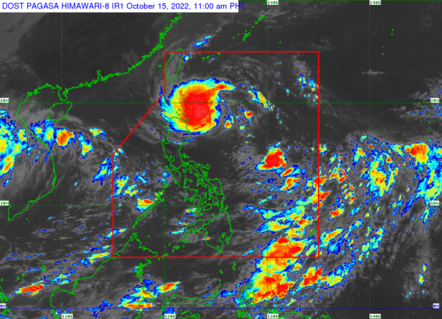
MANILA, Philippines — Tropical Depression Neneng will bring heavy rainfall on Saturday afternoon to parts of northern Luzon, where six areas are under Tropical cyclone Wind Signal Number 1, the state weather bureau said in its latest advisory.
The Philippine Atmospheric, Geophysical and Astronomical Services Administration (Pagasa) said that Batanes and Cagayan, including the Babuyan Islands, will experience heavy to intense and at times torrential rain.
Neneng, as of mid-day Saturday was spotted some 510 kilometers east of Calayan, Cagayan, with maximum sustained winds of 55 kilometers per hour (kph) near the center and gustiness of up to 70 kph.
Tropical Cyclone Wind Signal No. 1 is currently up over Batanes, Cagayan including the Babuyan Island, northern portion of Isabela (Santa Maria, San Pablo, Maconacon) Apayao, northern portion of Abra, (Tineg) and Ilocos Norte.
According to Pagasa’s 11am update, Apayao, Kalinga, Abra, Ilocos Norte will also experience moderate to heavy and at times intense rains, while the northern portion of Isabela and the rest of the Ilocos region and the Cordillera Administrative Region will experience lighter rainfall.
“Kasama na ang malalakas na hangin, may maraming ulan na dala itong si Neneng na maari ulit na makaka-apekto dito sa mga areas na na-apektuhan nitong si Bagyong Maymay, kaya patuloy ang ating paala-ala sa ating mga kababayan na maghanda dahil sa inaasahan nating pag-ulan,” Pagasa weather specialist Raymond Ordinario in the bureau’s afternoon weather forecast.
(Along with strong winds, Neneng will bring a lot of rain that will affect areas hit by Tropical Depression Maymay, that is why we are reminding our countrymen to be on alert and take extra precautions.)
Neneng is expected to exit the Philippine area of responsibility by Monday, said Pagasa.


