Neneng maintains strength, to be closest to Batanes, Babuyan Islands on Sunday
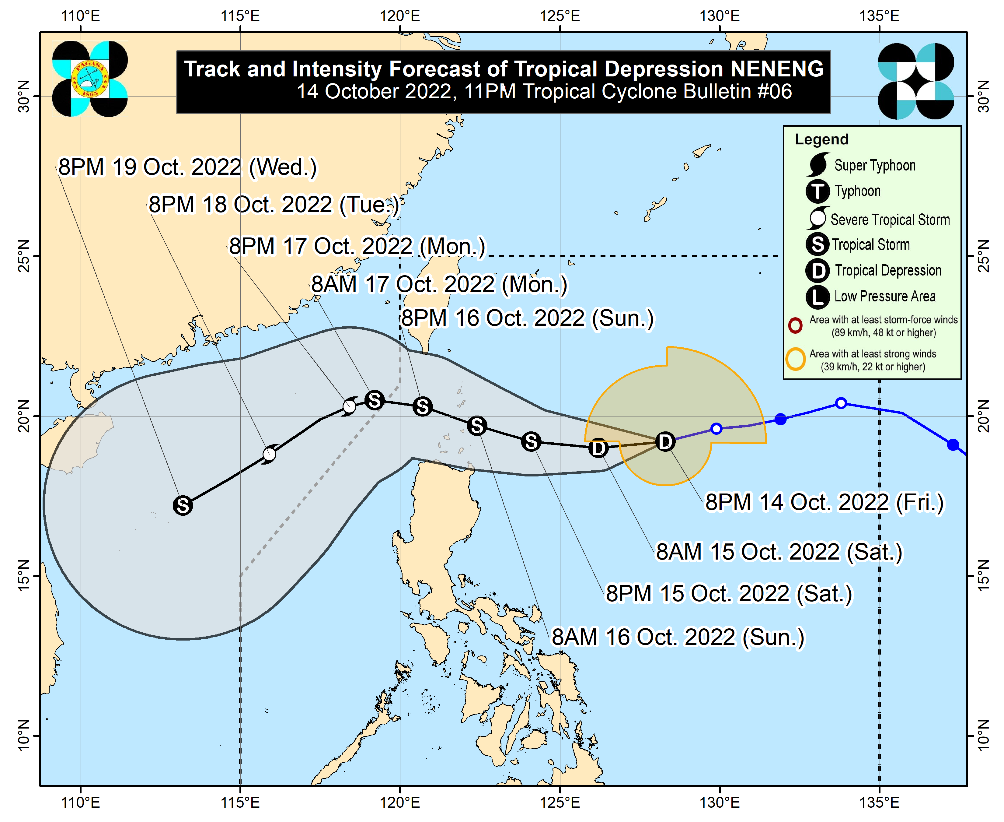
MANILA, Philippines — Tropical Depression Neneng was able to maintain its strength according to the state weather bureau on Friday night, while it is expected to be closest to Batanes province and Babuyan Islands by Sunday morning.
Weather updates from the Philippine Atmospheric, Geophysical and Astronomical Services Administration (Pagasa) showed that Neneng still has maximum sustained winds of 55 kilometers per hour (kph) and gustiness of up to 70 kph.
It was last seen 685 kilometers east of Calayan, Cagayan, and is moving west-northwest at a speed of 15 kph.
More areas were placed under Tropical Cyclone Wind Signal No. 1, namely:
- Batanes
- Cagayan including Babuyan Islands
- Eastern portion of Apayao (Luna, Santa Marcela, Flora, Pudtol)
- Extreme northern portion of Isabela (Santa Maria, San Pablo, Maconacon)
- Extreme northern portion of Ilocos Norte (Pagudpud, Bangui, Burgos)
Pagasa said that strong winds or strong breeze to near-gale strength winds will be experienced in the areas where Signal No. 1 is raised.
Article continues after this advertisementAs Neneng is still expected to intensify into a Tropical Storm-category cyclone as it moves closer to the country, Signal No. 2 may be raised by Pagasa. More areas may also be placed under Signal warnings.
Article continues after this advertisementCurrently, Pagasa expects the cyclone to continue moving west southwest, before making a slight northward nudge on Saturday morning. It would then continue moving towards Batanes and the Babuyan Islands, possibly crossing the Luzon Strait between Sunday morning and Sunday night.
By that time, Neneng would have intensified into a tropical storm.
It would then continue moving west-northwest and exit the Philippine area of responsibility by Monday morning. By Monday night, Pagasa expects Neneng to intensify further as a severe tropical storm.
While Pagasa’s cone of probability is still large, the chance of Neneng hitting mainland Luzon appears low as the cyclone would have to move southward and deviate from its current track. However, a landfall scenario is not yet ruled out, as state meteorologists say Neneng may pass very close over the vicinity of Babuyan Islands or Batanes either Sunday morning or afternoon.
Pagasa said that from Saturday morning to Saturday afternoon, light to moderate rains with at times heavy rains will be possible in Batanes, Cagayan, Babuyan Islands, Apayao, Kalinga, Ilocos Norte, and Abra.
After that and until Sunday evening, moderate to heavy rains with at times intense rains will likely persist in the said areas.
Meanwhile, the northern portion of Isabela, the rest of Ilocos Region, and the Cordillera Administrative Region would experience light to moderate with at times heavy rains during the same period.
“Under these conditions, scattered flooding and rain-induced landslides are possible, especially in areas that are highly or very highly susceptible to these hazards as identified in hazard maps and in localities with significant antecedent rainfall,” Pagasa warned.
“Considering these developments, the public and disaster risk reduction and management offices concerned are advised to take all necessary measures to protect life and property. Persons living in areas identified to be highly or very highly susceptible to these hazards are advised to follow evacuation and other instructions from local officials,” it added.
READ: Neneng intensifies; Signal No. 1 up in parts of Cagayan Valley — Pagasa