Source: DOST / Pagasa
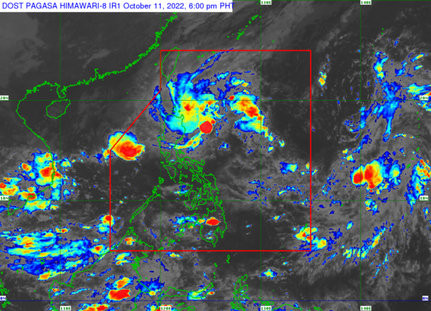
MANILA, Philippines — Tropical Cyclone Wind Signal No. 1 remains hoisted over several areas in Luzon as Tropical Depression “Maymay” lies almost stationary in the Philippine sea, said the Philippine Atmospheric, Geophysical and Astronomical Services Administration (Pagasa).
According to Pagasa weather specialist Veronica Torres, Maymay “lies almost stationary” in the Philippine sea as it moved westward slowly toward Central Luzon.
Source: DOST / Pagasa
It was last located 265 kilometers (kms) east of Casiguran, Aurora with maximum sustained winds of 45 km per hour (kph) and gustiness of up to 55 kph and is expected to make landfall in the vicinity of Aurora by Wednesday evening or Thursday early morning.
“Inaasahan natin na mananatili siyang tropical depression bago maglandfall, at habang binabaybay ang Central Luzon area maaari siyang bumaba at maging low pressure area,” Torres said.
(We expect it to remain a tropical depression before landfall, and while passing through the Central Luzon area it may deescalate into a low pressure area.)
Due to this moderate to heavy with at times intense rains are forecast over Cagayan, northern portion of Isabela, Batanes and Apayao, while moderate with at times heavy rainfall are expected over Aurora, Abra, Kalinga, Mountain Province and Ilocos Norte.
Tropical Wind Signal No. 1 (strong winds prevailing or expected within the next 36 hours) is raised over the following areas:
- Isabela
- Quirino
- Nueva Vizcaya
- Aurora
- Nueva Ecija
- Extreme Northern portion of Quezon including Polillo Islands
Meanwhile, the other tropical depression currently being monitored outside the Philippine area of responsibility was last located 1,965 east of Southern Luzon also carrying maximum sustained winds of 45 km per hour (kph) and gustiness of up to 55 kph.
RELATED STORY:
Tropical Depression Maymay nears PH landmass; expect heavy rain, strong winds – Pagasa